RAF Jurby
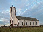
Royal Air Force Jurby, or more simply RAF Jurby, is a former Royal Air Force station built in the north west of the Isle of Man. It was opened in 1939 on 400 acres (1.6 km2) of land acquired by the Air Ministry in 1937, under the control of No. 29 Group, RAF. During the Second World War the station was used for training as No. 5 Armament Training Station, No. 5 Air Observer School, No. 5 Bombing & Gunnery School and the No. 5 Air Navigation & Bombing School. In addition RAF Jurby also played host to a variety of operational squadrons. RAF Jurby was originally a grass airfield but was later equipped with hard runways. Operationally it helped protect Belfast and Liverpool from German air raids, being strategically placed in order to offer fighter protection. During the 1950s and 60s the No. 1 Initial Training School (No. 1 ITS) subsequently replaced by the No. 1 Officer Cadet Training Unit (No. 1 OCTU) was based at RAF Jurby, jokingly referred to by the trainee cadets as "The Camp on Blood Island". Following the closure of the station in 1963, the airfield was used as a diversion for Ronaldsway Airport. To be able to accept Vickers Viscount turboprop airliners the main East–west runway was extended eastwards and bisected by the Ballamenagh Road (A14). To facilitate the use of the extended runway, barriers were placed across the road and the road was closed whilst the runway was in use.
Excerpt from the Wikipedia article RAF Jurby (License: CC BY-SA 3.0, Authors).RAF Jurby
Ballamenagh Road, Jurby
Geographical coordinates (GPS) Address Nearby Places Show on map
 Continue reading on Wikipedia
 Geographical coordinates (GPS)
| Latitude | Longitude |
|---|---|
| N 54.3525 ° | E -4.5080555555556 ° |
Address
Ballamenagh Road
Ballamenagh Road
Jurby
Isle of Man
Open on Google Maps