Ginger Hall
Geography of the Isle of ManIsle of Man geography stubsMotorcycle racing stubsRoads in the Isle of ManUse British English from April 2017

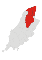
Ginger Hall is an uphill left-hand bend following Sulby Bridge on the Isle of Man TT course, a traditionally popular spectator and photographer vantage point with views of motorcycles approaching from Sulby Bridge and exiting towards Kerrowmoar. Situated on a corner-junction, the adjacent Ginger Hall Hotel dates from the mid-19th century and offers refreshments and access to another major viewing area at the Bungalow close to the summit of Snaefell mountain via the B8 Claddagh Road and the A14 Sulby Road.
Excerpt from the Wikipedia article Ginger Hall (License: CC BY-SA 3.0, Authors, Images).Ginger Hall
River Meadow Land, Lezayre
Geographical coordinates (GPS) Address External links Nearby Places Show on map
 Continue reading on Wikipedia
 Geographical coordinates (GPS)
| Latitude | Longitude |
|---|---|
| N 54.321 ° | E -4.471 ° |
Address
Ginger Hall Hotel (Ginger Hall)
River Meadow Land
IM7 2HB Lezayre
Isle of Man
Open on Google Maps
External links