place

Sa Riera

Fishing communitiesPopulated places in Baix EmpordàProvince of Girona geography stubs
Sa Riera beach
Sa Riera beach

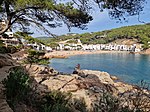
Sa Riera, Catalonia, Spain is a fishing village and holiday resort situated in a tranquil and secluded bay of the Costa Brava close to the nearby inland towns of Palafrugell and Begur. It can be reached by road from Begur and Pals and there is also a pleasant walk around the cliffs from Platja de Pals, the next resort along the coast. Sa Riera is typical of the many small coves set amongst rugged pine covered cliffs cascading down to meet the crystal clear waters of the Mediterranean Sea which have made the area north of Palamos and south of L'Estartit famous for its outstanding beauty. Originally a small fishing village, Sa Riera has not been overdeveloped and has retained its individuality and charm. Sa Riera has a beach that is sheltered and particularly popular in the summer months. There is also good snorkelling around the craggy rocks. There are some small hotels and good seafood restaurants, small cafes & bars.

Excerpt from the Wikipedia article Sa Riera (License: CC BY-SA 3.0, Authors, Images).

Sa Riera
Gerolfinger Straße, Ingolstadt

Geographical coordinates (GPS) Address Nearby Places
placeShow on map

Wikipedia: Sa RieraContinue reading on Wikipedia

Geographical coordinates (GPS)

Latitude Longitude
N 41.973038888889 ° E 3.2110611111111 °
placeShow on map

Address

Amphibien, Aquarium, Aras

Gerolfinger Straße
85049 Ingolstadt (Mitte)
Bayern, Deutschland
mapOpen on Google Maps

Sa Riera beach
Sa Riera beach
Share experience

Nearby Places

Begur, Spain
Begur, Spain

Begur is a village and municipality in the comarca of Baix Empordà and province of Girona in Catalonia, Spain. The village itself lies some 2 kilometres (1.2 mi) from, and 200 metres (660 ft) above, the coastline of the Costa Brava, but the municipality includes several seaside resorts.The municipality of Begur has 3,986 inhabitants (according to the census of 2005). It is an important tourist attraction in the Baix Empordà. During the summer, the population can exceed 40,000 people. Despite its tourist character, the village has important historical remnants that go back in early history. The castle of Begur is a good example of medieval remains. The castle was constructed in the 16th and 17th centuries. The municipality of Begur also includes Esclanyà (with a Romanesque old part), Aiguafreda, Sa Riera, Sa Tuna, Aiguablava and Fornells. Some of the most prestigious beaches of the Costa Brava can be found here: Sa Riera, Aiguafreda, sa Tuna, Platja Fonda (although it has been almost completely destroyed by storms), Fornells and Aiguablava. The latter is also home to a Parador Hotel. The annual festival to celebrate St. Tania takes places each November. The village of Begur is a staging point on the GR 92 long distance footpath, which runs the length of the Mediterranean coast of Spain. Stage 7, to the north, takes an inland route via Pals, Palau-sator, Fontanilles and Gualta to the next staging point at Torroella de Montgrí, a distance of 21.3 kilometres (13.2 mi). Stage 8, to the south, heads to Sa Tuna and Fornells de Mar before following the coast further south through Tamariu, Llafranc and Calella de Palafrugell to the next staging point at Palamós, a distance of 23.0 kilometres (14.3 mi).

Tamariu
Tamariu

Tamariu (Catalan pronunciation: [təməˈɾiw], Catalan for tamarisk) is one of three coastal towns belonging to the municipality of Palafrugell, province of Girona, Spain, the other two being Calella de Palafrugell and Llafranc. It is part of the Costa Brava, the coastal region of northeastern Catalonia, in the comarca of Baix Empordà. It is situated about 70 mi (110 km) south of the border with France and close to the nearby inland towns of Palafrugell and Begur.The name Tamariu derives from the presence of many tamarisk trees along the promenade, which separates the beach from the narrow streets and whitewashed buildings of the town. Tamariu was originally a small fishing village, and fishing boats are still to be seen drawn up on the beach. Today they have been joined by a few hotels, along with seafood restaurants, cafes and bars.Tamariu is set amongst rugged pine covered cliffs flanking the Mediterranean Sea. The crystal clear waters around this area are amongst the purest on the coast. The south-facing blue flag beach is ideal for swimming as the it shelves at a fairly gentle angle. It is also popular as a dive site as there are many caves to explore along with the submerged mountain of the Llosa de Cala Nova.The GR 92 long distance footpath, which runs the length of the Mediterranean coast of Spain, passes through the town. To the north the path takes an inland route through pine and cork oak forests to the beach at Aiguablava before following the coast to Fornells. To the south the path follows an, in places rough, track above the shore line to the beach at Cala Pedrosa, the Sant Sebastià lighthouse, and the town of Llafranc.Aigua Gelida is the largest urbanisation in Tamariu filling the gap between Tamariu and Aiguablava. Aigua Gelida has a small sandy cove predominantly for residents of Cala Nostra just 300m away. Building restrictions are not as strict in Aigua Gelida and so many modern villas have been built in the past few years.

Llafranc
Llafranc

Llafranc (Catalan pronunciation: [ʎəˈfɾaŋ]) is one of three coastal towns belonging to the municipality of Palafrugell, province of Girona, Spain, the other two being Calella de Palafrugell and Tamariu. It is part of the Costa Brava, the coastal region of northeastern Catalonia, in the comarca of Baix Empordà.Many domestic tourists come from nearby Barcelona, while the international tourists come from a whole range of countries, especially the Netherlands, England, France, and more recently the United States. The Hotel Llafranc dominates the main sea promenade and was popular with artists such as Rock Hudson, Sophia Loren, Elizabeth Taylor, Salvador Dalí and Ernest Hemingway. The English writer Tom Sharpe was also a resident of Llafranc.The town is overlooked by the historical site of Sant Sebastià de la Guarda, located on a headland 1.5 kilometres (0.93 mi) to the north, and 168 metres (551 ft) above, Llafranc beach. It comprises the ruins of a settlement of the Iberians from the 6th-1st centuries BCE, a 15th-century watchtower and the 19th century Sant Sebastià lighthouse. The lighthouse, which is still operational, has a range of 32 nautical miles (59 km; 37 mi) and is the most powerful on the Catalan coast. The residential district of El Far, which takes its name from the lighthouse, lies below the headland.The GR 92 long distance footpath, which runs the length of the Mediterranean coast of Spain, passes through the town. To the north the path follows the road up to the lighthouse and then uses an in places rough, track above the shore line to the beach at Cala Pedrosa and the town of Tamariu. To the south the path follows the coast the short distance to Calella de Palafrugell, passing the 16th century Torre de Calella on the way.Commerce and civic organizations gather under the Associació d'Amics de Llafranc, which elects a president every 4 years in order to represent this small town in the City Council of Palafrugell, its main municipality.