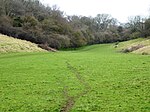
Elham Valley
Folkestone and Hythe DistrictKent geography stubsValleys of Kent

The Elham Valley is a chalk valley carved by the River Nailbourne situated in the North Downs in East Kent. The valley is named after the settlement of Elham. Other settlements in the valley include Etchinghill, Lyminge, Barham, Kingston, Bishopsbourne and Bridge. Located in the upper slopes of the valley are a number of examples of unimproved chalk downland such as Baldock Downs and Park Gate Down. At Bishopsbourne and North Lyminge there are examples of traditional sheep-grazed pasture and water meadow.
Excerpt from the Wikipedia article Elham Valley (License: CC BY-SA 3.0, Authors, Images).Elham Valley
St. Marys Road, Folkestone and Hythe District
Geographical coordinates (GPS) Address Nearby Places Show on map
Geographical coordinates (GPS)
| Latitude | Longitude |
|---|---|
| N 51.1528 ° | E 1.1111 ° |
Address
St. Marys Road
CT4 6TJ Folkestone and Hythe District
England, United Kingdom
Open on Google Maps


