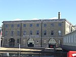
Fort Cumberland (England)
1747 establishments in England18th-century fortifications1970s disestablishments in EnglandEnglish Heritage sites in HampshireForts in Portsmouth ... and 8 more
Grade II* listed buildings in HampshireGrade II* listed fortsMilitary installations closed in the 1970sMilitary installations established in 1747Napoleonic war forts in EnglandPalmerston FortsPrince William, Duke of CumberlandUse British English from January 2021

Fort Cumberland is a pentagonal artillery fortification erected to guard the entrance to Langstone Harbour, east of the Dockyard of Portsmouth on the south coast of England. It was sited to protect the Royal Navy Dockyard, by preventing enemy forces from landing in Langstone Harbour and attacking from the landward side. Fort Cumberland is widely recognised as the finest example of a bastion trace fort in England. It is a scheduled monument and a Grade II* listed building
Excerpt from the Wikipedia article Fort Cumberland (England) (License: CC BY-SA 3.0, Authors, Images).Fort Cumberland (England)
Fort Cumberland Road, Portsmouth Eastney
Geographical coordinates (GPS) Address Website Nearby Places Show on map
Geographical coordinates (GPS)
| Latitude | Longitude |
|---|---|
| N 50.788888888889 ° | E -1.0325 ° |
Address
English Heritage Centre for Archaeology, Fort Cumberland
Fort Cumberland Road
PO4 9LD Portsmouth, Eastney
England, United Kingdom
Open on Google Maps


