Brookland (Washington, D.C.)

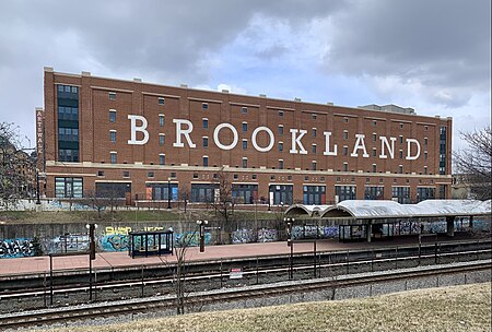
Brookland (also known as Little Rome) is a neighborhood located in the Northeast (NE) quadrant of Washington, D.C. It is best known for its numerous Catholic institutions, including schools, religious communities, shrines, institutes, and other organizations built and based around the Catholic University of America. Historically centered along 12th Street NE, Brookland is bounded by Taylor Street NE and Michigan Avenue NE to the northwest; by Rhode Island Avenue NE to the southeast; by South Dakota Avenue NE to the northeast; and by subway (Washington Metro's Red Line) and train (CSX) tracks to the west.The western boundary of the railroad tracks originated with the completion of the former Metropolitan Branch of the Baltimore and Ohio Railroad in 1873, which now incorporates the Washington Metro's Red Line. The railroad and subway tracks create the physical barrier that has separated Brookland from the Edgewood neighborhood to the west. The Washington Metropolitan Area Transit Authority (WMATA) provides public transportation services to and throughout Brookland, with two subway stations and several bus lines. Most of the Brookland neighborhood is served by the Washington Metropolitan Area Red Line Brookland–CUA Metro station, located between Monroe Street NE and Michigan Avenue NE. A small portion of the Brookland neighborhood located on Rhode Island Avenue NE is served by the Red Line Rhode Island Avenue Metro Station.
Excerpt from the Wikipedia article Brookland (Washington, D.C.) (License: CC BY-SA 3.0, Authors, Images).Brookland (Washington, D.C.)
Hamlin Street Northeast, Washington
Geographical coordinates (GPS) Address Nearby Places Show on map
Geographical coordinates (GPS)
| Latitude | Longitude |
|---|---|
| N 38.9275 ° | E -76.99 ° |
Address
Hamlin Street Northeast 1201
20017 Washington
District of Columbia, United States
Open on Google Maps


