Stelling van Amsterdam

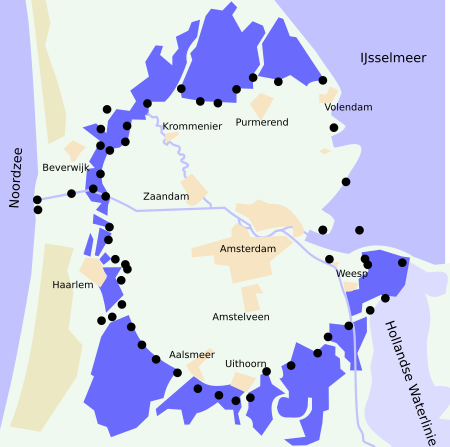
The UNESCO World Heritage Site known as the Defence Line of Amsterdam (in Dutch named Stelling van Amsterdam, pronounced [ˌstɛlɪŋ vɑn ɑmstərˈdɑm]) is a 135-kilometre (84 mi) ring of fortifications around Amsterdam. It has 42 forts that are 10–15 kilometres (6.2–9.3 mi) from the centre and lowlands, which can easily be flooded in time of war. The flooding was designed to give a depth of about 30 centimetres (12 in), too little for boats to cross. Any buildings within 1 kilometre (0.62 mi) of the line had to be made of wood so that they could be burnt and the obstruction removed. The Stelling van Amsterdam was constructed between 1880 and 1920. The invention of the aeroplane and tank made the forts obsolete almost as soon as they were finished. Many of the forts now are under the control of both the town councils and the nature department. They may be visited by the public, and admission is free on Monuments Day, the second Saturday in September.
Excerpt from the Wikipedia article Stelling van Amsterdam (License: CC BY-SA 3.0, Authors, Images).Stelling van Amsterdam
Gravenstraat, Amsterdam Centrum
Geographical coordinates (GPS) Address Website Nearby Places Show on map
Geographical coordinates (GPS)
| Latitude | Longitude |
|---|---|
| N 52.374444444444 ° | E 4.8930555555556 ° |
Address
Café Belgique
Gravenstraat 2
1012 NM Amsterdam, Centrum
North Holland, Netherlands
Open on Google Maps


