Mayfield Park, Bristol
Areas of Bristol
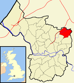
Mayfield Park is a residential area in East Bristol, with a large adjoining park known as the Ridgeway Rd Playing Fields.The area is located on the outskirts of the outer urban area of Fishponds and consists mainly of four roads: Mayfield Park, Mayfield Park North, Mayfield Park South and Mayfield Avenue. It is also near the main road of Berkeley Road and the outer urban area with the name of Speedwell, and adjacent to Chester Park. The area has a population of 1,730 (est).
Excerpt from the Wikipedia article Mayfield Park, Bristol (License: CC BY-SA 3.0, Authors).Mayfield Park, Bristol
Laburnum Grove, Bristol Fishponds
Geographical coordinates (GPS) Address Nearby Places Show on map
Geographical coordinates (GPS)
| Latitude | Longitude |
|---|---|
| N 51.4805 ° | E -2.5241 ° |
Address
Laburnum Grove 9
BS16 3TJ Bristol, Fishponds
England, United Kingdom
Open on Google Maps


