place

Crew's Hole, Bristol

Areas of BristolEngvarB from October 2013
Quayside Village Bristol

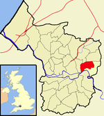
Crew's Hole is an area in east Bristol near St George. It is next to the River Avon, two miles upstream from Bristol Bridge.From the early 18th century it began to be used extensively as an industrial area. The Bristol Brass Company began copper smelting in 1810 at Crew's Hole, and later expanded with a chimney further uphill which gave a better draught condition for the furnaces. Anthony Ammatt established a pottery at Crew's Hole in 1812, using clay transported from the Isle of Wight and Poole. Several bargeworks were built here during the 19th century.

Excerpt from the Wikipedia article Crew's Hole, Bristol (License: CC BY-SA 3.0, Authors, Images).

Crew's Hole, Bristol
The Avenue, Bristol St George

Geographical coordinates (GPS) Address Nearby Places
placeShow on map

Wikipedia: Crew's Hole, BristolContinue reading on Wikipedia

Geographical coordinates (GPS)

Latitude Longitude
N 51.4592 ° E -2.5411 °
placeShow on map

Address

The Avenue

The Avenue
BS5 8HL Bristol, St George
England, United Kingdom
mapOpen on Google Maps

Quayside Village Bristol
Share experience

Nearby Places

Netham Lock
Netham Lock

Netham Lock (grid reference ST616727) is the point at Netham in Bristol at which boats from the River Avon, acting as part of the Kennet and Avon Canal, gain access to Bristol's Floating Harbour. Construction started in 1804 to build the tidal New Cut and divert the River Avon along the Feeder Canal to the harbour; a system designed and built by William Jessop and later improved by Isambard Kingdom Brunel.A weir carries the river into the New Cut and boats use the adjacent lock. High tides often pass over the weir, and the river is effectively tidal to the next lock upstream at Hanham. Some spring tides can also pass over the weir at Hanham, making the river tidal as far as Keynsham Lock.Access to the harbour is only possible during the day when the lock keeper will open the gates unless the water level in the river between Netham and Hanham is above or below the level of the harbour.The maximum dimensions of a vessel which can pass through Netham Lock are: Length: 24.4 metres (80 ft) Beam: 5.4 metres (18 ft) Draught: 1.9 metres (6.2 ft) Headroom: 3.1 metres (10 ft)The lock-keeper's cottage, built in the early nineteenth century, is a grade II listed building and has a plaque listing it as Bristol Docks building number 1. The floral displays around the cottage and on the banking have attracted praise.Netham Lock and the weir form part of Bristol's flood defence mechanisms and it was announced in December 2008 that they would be upgraded as part of the £11 million City Docks Capital Project.