Crofts End
Areas of BristolPlaces formerly in GloucestershireVague or ambiguous time from August 2024
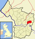
Crofts End, also known as Clay Hill, is a suburban neighbourhood of Bristol, England, 2+1⁄2 miles (4 km) northeast of The Centre in the Eastville electoral ward. It is an industrialised area, with many small Victorian terraced houses, built when this area was a coal mining community. Crofts End borders Eastville to the northwest, Whitehall to the southwest, St George to the south, and Speedwell to the east. To the northeast, it is separated from Fishponds by Ridgeway playing fields and Coombe Brook Nature Reserve.
Excerpt from the Wikipedia article Crofts End (License: CC BY-SA 3.0, Authors).Crofts End
Deep Pit Road, Bristol Speedwell
Geographical coordinates (GPS) Address Nearby Places Show on map
Geographical coordinates (GPS)
| Latitude | Longitude |
|---|---|
| N 51.468 ° | E -2.541 ° |
Address
Deep Pit Road 26
BS5 7UF Bristol, Speedwell
England, United Kingdom
Open on Google Maps


