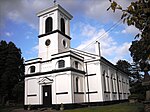
Bridgemere

Bridgemere is a village (at SJ717454) and former civil parish, now in the parish of Doddington and District, in the unitary authority area of Cheshire East and the ceremonial county of Cheshire, England. It is around 7 miles (11 km) south east of Nantwich and 12 miles (19 km) west of Stoke-on-Trent. The southern boundary of the parish is on the border with Shropshire. The civil parish also included the small settlements of Admiral's Gorse, Parrah Green, Prince Hill, Seven Stars and Wheel Green. In 2011 the parish had a population of 148. Nearby towns include Crewe in Cheshire, Market Drayton and Whitchurch in Shropshire, and villages include Blakenhall, Buerton and Hankelow in Cheshire, Madeley, Staffordshire and Woore, Shropshire.
Excerpt from the Wikipedia article Bridgemere (License: CC BY-SA 3.0, Authors, Images).Bridgemere
Dingle Lane,
Geographical coordinates (GPS) Address Nearby Places Show on map
Geographical coordinates (GPS)
| Latitude | Longitude |
|---|---|
| N 53.006 ° | E -2.423 ° |
Address
Dingle Lane
Dingle Lane
CW5 7PF , Doddington and District
England, United Kingdom
Open on Google Maps


