place

Montfort, Netherlands

Former municipalities of Limburg (Netherlands)Limburg (Netherlands) geography stubsPopulated places in Limburg (Netherlands)Roerdalen
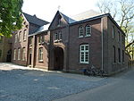
Montfort (Roerdalen) Roerdriehoekmuseum

Montfort (Limburgish: Mofert) is a small city in the Dutch province of Limburg. Montfort has about 3,000 inhabitants. It lies about 8 km south of Roermond. It received city rights in 1271 and is renowned for the ruins of Castle Montfort, built in the 13th century. Until 1991, Montfort was a separate municipality. It then became part of Posterholt, which was later renamed Ambt Montfort.Since 1 January 2007, Montfort has been part of the municipality of Roerdalen.

Excerpt from the Wikipedia article Montfort, Netherlands (License: CC BY-SA 3.0, Authors, Images).

Montfort, Netherlands
Waarderweg, Roerdalen

Geographical coordinates (GPS) Address Nearby Places
placeShow on map

Wikipedia: Montfort, NetherlandsContinue reading on Wikipedia

Geographical coordinates (GPS)

Latitude Longitude
N 51.129166666667 ° E 5.9458333333333 °
placeShow on map

Address

Waarderweg 2
6065 EX Roerdalen
Limburg, Netherlands
mapOpen on Google Maps

Montfort (Roerdalen) Roerdriehoekmuseum
Share experience

Nearby Places

Pepinusbrug
Pepinusbrug

Pepinusbrug is a hamlet south-east of Pey in the Dutch municipality Echt-Susteren. The name Pepinusbrug originates from a legend about Pepin of Herstal, who was the lord of the Frankish kingdom. According to this legend, he went on an annual pilgrimage from his hometown of Herstal to the monastery on Mount Petrus (nowadays known as Sint Odiliënberg), which was supposedly founded by saints Wiro of Roermond, Plechelmus, and Otgerus. On his way to this monastery, Pepin got stuck in the vast swamps south of Echt, but a few neighbors saved him from drowning. Pepin was so grateful to the inhabitants of Echt that he donated a large piece of land and had a dyke and bridge built across the swamp. Nowadays the reliability of this legend is doubted. It was first recorded in 1477 in the 'Cleernis van de gemeynte van Echt'. In this document the people of Echte ask their lord, the duke of Gelre, for protection against attacks from the neighbouring duke of Gulik. In return for the protection offered, the Duke of Gelre stipulated that the citizens of Echt should receive one third of the land from the donation of Pepin of Herstal, thus acknowledging the donation of Pepin of Herstal. In November 1940, the legend was also told to the Reich Commissioner of the occupied Netherlands, Arthur Seyss-Inquart, during his visit to the province of Limburg. The latter was so interested in the story that he commissioned architect Hendrik Willem Valk to design a new Pepinus bridge decorated with episodes from the legend, but this design was never executed.In 1883, a Cistercian monastery opened in Pepinusbrug. In 1912, it was elevated to Lilbosch Abbey. Pepinusbrug does not have place name signs, and consists of about 40 houses excluding the care facility Pergamijn which is home to about 200 people.