Tung Shan (mountain)
Hong Kong mountain stubsMountains, peaks and hills of Hong KongNew TerritoriesNew Territories geography stubsSai Kung District

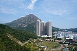
Tung Shan (Chinese: 東山; Cantonese Yale: dūng shāan; lit. 'East Mountain') is a mountain between Tate's Cairn and Kowloon Peak in Kowloon, Hong Kong. Its summit is 544 m (1,818 ft) high.
Excerpt from the Wikipedia article Tung Shan (mountain) (License: CC BY-SA 3.0, Authors, Images).Tung Shan (mountain)
Fei Ngo Shan Road, Sai Kung District
Geographical coordinates (GPS) Address Nearby Places Show on map
 Continue reading on Wikipedia
 Geographical coordinates (GPS)
| Latitude | Longitude |
|---|---|
| N 22.352812 ° | E 114.221495 ° |
Address
飛鵝山觀景台 Kowloon Peak Viewing Point
Fei Ngo Shan Road
000000 Sai Kung District (Wong Tai Sin District)
Hong Kong, China
Open on Google Maps