Waterrock Knob
Blue Ridge ParkwayLandforms of Jackson County, North CarolinaLandmarks in North CarolinaMountains of Haywood County, North CarolinaMountains of North Carolina ... and 4 more
Protected areas of Haywood County, North CarolinaProtected areas of Jackson County, North CarolinaSouthern SixersWestern North Carolina geography stubs

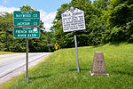
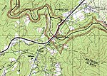
Waterrock Knob is a mountain peak in the U.S. state of North Carolina. It is the highest peak in the Plott Balsams and is the 16th-highest mountain in the Eastern United States. The mountain is a popular destination with tourists and amateur hikers, as it is easily accessible from the Blue Ridge Parkway. A visitors' center is located near its summit and a hiking trail leads to its top. The hiking trail and visitors' center are staffed and maintained by the National Park Service, part of the United States Department of the Interior.
Excerpt from the Wikipedia article Waterrock Knob (License: CC BY-SA 3.0, Authors, Images).Waterrock Knob
Waterrock Knob Trail,
Geographical coordinates (GPS) Address Nearby Places Show on map
Geographical coordinates (GPS)
| Latitude | Longitude |
|---|---|
| N 35.464268 ° | E -83.137643 ° |
Address
Waterrock Knob Trail
Waterrock Knob Trail
North Carolina, United States
Open on Google Maps


