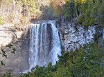
place

Grey Highlands

Lower-tier municipalities in OntarioMunicipalities in Grey CountyNiagara EscarpmentPages with non-numeric formatnum argumentsUse Canadian English from January 2023
Grey Highlands ON
Grey Highlands ON

Grey Highlands is a municipality in the southeast corner of Grey County, Ontario, Canada. It was formed on January 1, 2001, by the amalgamation of the village of Markdale and the townships of Artemesia, Euphrasia and Osprey, which included the unincorporated hamlets of Eugenia, Ceylon, Maxwell, Singhampton, Priceville, Kimberley, Badjeros, and Feversham. The former village of Flesherton is also located within the municipality and was amalgamated with Artemesia Township in 1998. According to the 2016 census, the municipality covers a land area of 882 square kilometres and has a population of 9,804. The municipality has a healthy population growth, and its average age (43 years old) is close to that of the provincial average (41 years old). The average household size is 2.5, and the average total income of all households is $94,000. The average after-tax income of households in the municipality is $77,000.

Excerpt from the Wikipedia article Grey Highlands (License: CC BY-SA 3.0, Authors, Images).

Geographical coordinates (GPS)

Latitude Longitude
N 44.333333333333 ° E -80.5 °
placeShow on map

Address

Grey Highlands


Grey Highlands
Ontario, Canada
mapOpen on Google Maps

Website
greyhighlands.ca

linkVisit website

linkWikiData (Q3492513)
linkOpenStreetMap (7478454)

Grey Highlands ON
Grey Highlands ON
Share experience

Nearby Places

Wareham, Ontario
Wareham, Ontario

Wareham is a community in Grey County, Ontario. It is about 80 km northwest of Brampton, Ontario and about 60 km west of Barrie, Ontario. It is south of The Blue Mountains, Ontario and of the Grey Highlands. Wareham is close to the Osprey Wetland Conservation Lands. Both the Saugeen Valley Conservation Authority and the Nottawasaga Valley Conservation Authority bought land here to protect the headwaters of several important rivers. The Osprey Wetlands are in the headwaters of the Saugeen River, as well as the Grand, the Beaver of Grey County, the Mad, and a tributary of the Nottawasaga River. This Wetland is a raised bog. " Wareham as a community dates back to roughly the European Settlement of this area, about the 1850s. A branch of the Saugeen River runs through the centre of Wareham - and was the reason for settlement here. (The current crossroads of Centre Line A and Sideroad 41.) Originally there were three small water mills grouped around this corner. Remains of one of the largest of these, in the form of poured concrete bracketing the river, can be found to the SE, upstream from the intersection. The Hamlet of Wareham originally included a general store (now the location of the Church Shed / Wareham Forge) on the NW corner, and a blacksmith's shop on the NE corner. A red brick church, located about 50 m to the west on Centre Line, replaced the original wooden structure on the Davison farm about a mile east of the current location, about 1930. The original wood frame school house is located on the east side of SR 41, about 150 m south. (Both the church and the schoolhouse are now private residences.) " It is the home of Darrell Markewitz, an artisan blacksmith who designed the living history program for L'Anse aux Meadows, Newfoundland for Parks Canada. The Wareham Forge has been in operation since 1992 (the old 'Wareham Church Shed' building).