Kanheri Caves

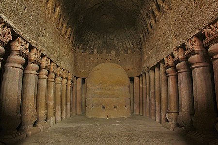
The Kanheri Caves (Kānherī-guhā [kaːnʱeɾiː ɡuɦaː]) are a group of caves and rock-cut monuments cut into a massive basalt outcrop in the forests of the Sanjay Gandhi National Park, on the former island of Salsette in the western outskirts of Mumbai, India. They contain Buddhist sculptures and relief carvings, paintings and inscriptions, dating from the 1st century CE to the 10th century CE. Kanheri comes from the Sanskrit Krishnagiri, which means black mountain.The site is on a hillside, and is accessible via rock-cut steps. The cave complex comprises one hundred and nine caves. The oldest are relatively plain and unadorned, in contrast to later caves on the site, and the highly embellished Elephanta Caves of Mumbai. Each cave has a stone plinth that functioned as a bed. A congregation hall with huge stone pillars contains a stupa (a Buddhist shrine). Rock-cut channels above the caves fed rainwater into cisterns, which provided the complex with water. Once the caves were converted to permanent monasteries, their walls were carved with intricate reliefs of Buddha and the Bodhisattvas. Kanheri caves were built in the 1st century and had become an important Buddhist settlement on the Konkan coast by the 3rd century CE. Most of the caves were Buddhist viharas, meant for living, studying, and meditating. The larger caves, which functioned as chaityas, or halls for congregational worship, are lined with intricately carved Buddhist sculptures, reliefs, pillars and rock-cut stupas. Avalokiteshwara is the most distinctive figure. The large number of viharas demonstrates there was a well organized establishment of Buddhist monks. This establishment was also connected with many trade centers, such as the ports of Sopara, Kalyan, Nasik, Paithan and Ujjain. Kanheri was a University center by the time the area was under the rule of the Maurayan and Kushan empires. In the late 10th century, the Buddhist teacher Atisha (980–1054) came to the Krishnagiri Vihara to study Buddhist meditation under Rahulagupta.
Excerpt from the Wikipedia article Kanheri Caves (License: CC BY-SA 3.0, Authors, Images).Kanheri Caves
Kanheri Caves Road, Mumbai R/C Ward (Zone 4)
Geographical coordinates (GPS) Address Nearby Places Show on map
Geographical coordinates (GPS)
| Latitude | Longitude |
|---|---|
| N 19.208333333333 ° | E 72.906388888889 ° |
Address
Cave 63
Kanheri Caves Road
400101 Mumbai, R/C Ward (Zone 4)
Maharashtra, India
Open on Google Maps


