Hythe Lifeboat Station
Folkestone and Hythe DistrictLifeboat stations in KentUse British English from July 2024

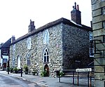
Hythe Lifeboat Station was located at the eastern end of West Parade, in the market town of Hythe, which is situated 7 miles (11 km) west of Folkestone, on the Kent coast. A lifeboat station was first established here in 1893 by the Royal National Lifeboat Institution (RNLI), following the closure of the Hythe, Sandgate & Folkestone station at Seabrook. Hythe lifeboat station was closed in 1940, after the lifeboat was lost during the Dunkirk evacuation.
Excerpt from the Wikipedia article Hythe Lifeboat Station (License: CC BY-SA 3.0, Authors, Images).Hythe Lifeboat Station
Range Road, Folkestone and Hythe District Orchard Valley
Geographical coordinates (GPS) Address External links Nearby Places Show on map
Geographical coordinates (GPS)
| Latitude | Longitude |
|---|---|
| N 51.064527777778 ° | E 1.0781388888889 ° |
Address
The Lazy Shack
Range Road
CT21 6HG Folkestone and Hythe District, Orchard Valley
England, United Kingdom
Open on Google Maps


