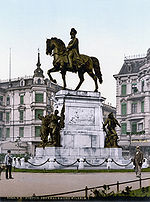
Polish Soldier Square
1725 establishments in the Holy Roman EmpireAvenues (landscape)Centrum, SzczecinInfrastructure completed in the 1720sOld Town, Szczecin ... and 1 more
Squares in Szczecin

The Polish Soldier Square, also commonly referred to as the Flower Avenue, is an urban square in Szczecin, Poland, located at the bounry of neighbourhoods of Centrum and Old Town, within the Downtown district. To the north and south of the square are placed roads, which intersect with Independence Avenue, Emancipation Avenue, Pope John Paul II Avenue, and Bałuki Street to the west, and with Jana Matejki Street and Castle Way to the east. The square was established in 1725, and was formerly known as the White Parade Square until 1809, and later as the King Square until 1945.
Excerpt from the Wikipedia article Polish Soldier Square (License: CC BY-SA 3.0, Authors, Images).Polish Soldier Square
aleja Kwiatowa, Szczecin Centrum
Geographical coordinates (GPS) Address Nearby Places Show on map
Geographical coordinates (GPS)
| Latitude | Longitude |
|---|---|
| N 53.428388888889 ° | E 14.554888888889 ° |
Address
aleja Kwiatowa
aleja Kwiatowa
70-551 Szczecin, Centrum
West Pomeranian Voivodeship, Poland
Open on Google Maps


