Zesławicki Lagoon

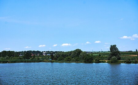
Zesławicki Lagoon (Polish: Zalew Zesławicki – two artificial reservoirs with a causeway lined with concrete slabs in the middle of them. The lagoon is an open landscape on the border of Kraków (Mistrzejowice District XV), Raciborowice (gmina Michałowice) and Batowice (gmina Zielonki) as the water intake for some osiedles of Nowa Huta. The name of the lagoon is derived from Zesławice, a former village attached to Nowa Huta and later incorporated into Kraków in the area where dams and reservoirs were built. The height above sea level of the lagoon is around 215 metres. It is bordered to the south by Gustawa Morcinka Street, to the east by Ku Raciborowicom Street, to the north by No.8 railway track, and to the west the third reservoir once planned. The lagoon is fed by River Dłubina, across which is a weir controlling the water level as it flows from the reservoirs. The lagoon was built in the 50s of 20th century. In principle it had resigned from carrying out its original function in the mid-80s of 20th century when the construction of Lake Dobczyce began.
Excerpt from the Wikipedia article Zesławicki Lagoon (License: CC BY-SA 3.0, Authors, Images).Zesławicki Lagoon
Gustawa Morcinka, Krakow Wzgórza Krzesławickie (Wzgórza Krzesławickie)
Geographical coordinates (GPS) Address Nearby Places Show on map
Geographical coordinates (GPS)
| Latitude | Longitude |
|---|---|
| N 50.107777777778 ° | E 20.0325 ° |
Address
Gustawa Morcinka
31-761 Krakow, Wzgórza Krzesławickie (Wzgórza Krzesławickie)
Lesser Poland Voivodeship, Poland
Open on Google Maps


