Piton de la Petite Rivière Noire
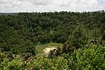
Piton de la Petite Rivière Noire (Little Black River Peak) is the highest mountain on the island of Mauritius, in the Indian Ocean. Located in the Rivière Noire District and rising to a height of 828 m (2,717 ft) above sea level, it forms part of the Black River mountain range. There are two other main mountain ranges in Mauritius: Moka-Port Louis and Grand Port-Savanne. The Moka-Port Louis range includes Pieter Both (820 m) and Le Pouce (811 m) mountains, the second and third highest summits respectively. Both are more famous than Piton de la Petite Rivière Noire in the southwest. The summit of Piton de la Petite Riviere Noire can be reached by various paths, the most common route is from Plaine Champagne, however there are routes from Chamarel and also from the Black River Gorges Visitors centre. On the summit there is a bench called "Bench 828".
Excerpt from the Wikipedia article Piton de la Petite Rivière Noire (License: CC BY-SA 3.0, Authors).Piton de la Petite Rivière Noire
Piste Machabée / Machabée Trail,
Geographical coordinates (GPS) Address Nearby Places Show on map
 Continue reading on Wikipedia
 Geographical coordinates (GPS)
| Latitude | Longitude |
|---|---|
| N -20.4 ° | E 57.466666666667 ° |
Address
Piste Machabée / Machabée Trail
Piste Machabée / Machabée Trail
Black River, Mauritius
Open on Google Maps