place

Adobe Rock

Geologic formations of UtahRock formations of Utah
Adobe Rock
Adobe Rock

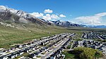
Adobe Rock is described by the USGS as a pediment (geology) at Lake Point, Utah. The large rock outcropping sits adjacent to SR-36 just north of SR-138 at Mills Junction. Because of its distance from the steep incline of the Oquirrh Mountains and its prominent location on the edge of a hill, Adobe Rock has served as a natural landmark in Tooele Valley ever since the first pioneers traversed the Hastings Cutoff trail. Though not officially a national monument like its nearby peer Black Rock (Great Salt Lake), it has equal significance as a navigating landmark and cultural significance as a monument with businesses using the Adobe Rock name, books using its images on their covers, and Lake Point, Utah depicting its likeness as their city logo.

Excerpt from the Wikipedia article Adobe Rock (License: CC BY-SA 3.0, Authors, Images).

Adobe Rock
State Route 36,

Geographical coordinates (GPS) Address Nearby Places
placeShow on map

Wikipedia: Adobe RockContinue reading on Wikipedia

Geographical coordinates (GPS)

Latitude Longitude
N 40.660056 ° E -112.288444 °
placeShow on map

Address

Adobe Rock

State Route 36
84704
Utah, United States
mapOpen on Google Maps

Adobe Rock
Adobe Rock
Share experience

Nearby Places

Stansbury Park, Utah

Stansbury Park is a census-designated place (CDP) in Tooele County, Utah, United States. As of the 2020 United States Census, the population was 9,851, up from the 2010 figure of 5,145. Stansbury Park is located in the northern end of Tooele Valley at the base of the Oquirrh Mountains. Traveling by Interstate 80, Stansbury Park is 35 minutes from downtown Salt Lake City. Stansbury Park was proposed by the original developer (Terracor) as a planned community with a lake for sailing and canoeing, an eighteen-hole golf course, clubhouse, swimming pool, and parks. Although the original developer withdrew from the scene in the 1980s due to bankruptcy, that plan has generally been followed. The parks throughout Stansbury Park include baseball diamonds, soccer fields, basketball courts, tennis courts, play areas for children, skateboard park, and an astronomical observatory. A large park northwest of Utah State Route 138 is being developed. A natural lake (The Mill Pond) exists on the northern edge of the area; it is fed by a spring at its southeast end. The outflow water from this lake is piped around the Oquirrh Mountain Range (east of Stansbury Park) to the Kennecott Company's copper mine refinery operation (the runoff water from the lake enters a large pipe NW of the Benson Grist Mill for transport to the Kennecott operation). The area includes several businesses, clustered in two developments at the southeast and northeast corners of the area along Utah State Route 36. As of 2019, the community is not incorporated; thus all municipal services (except for water and sewer service) are provided by Tooele County. A proposal to incorporate was voted down in November 2016.