place

Galabovtsi

Sofia Province geography stubsVillages in Sofia Province

Galabovtsi (Bulgarian: Гълъбовци) is a village in Slivnitsa Municipality, Sofia Province, located in western Bulgaria approximately 7 km south of the town of Slivnitsa.

Excerpt from the Wikipedia article Galabovtsi (License: CC BY-SA 3.0, Authors).

Geographical coordinates (GPS)

Latitude Longitude
N 42.809722222222 ° E 23.008888888889 °
placeShow on map

Address


2223 Slivnitsa
Bulgaria
mapOpen on Google Maps

Share experience

Nearby Places

Delyan, Sofia Province

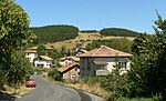
Delyan (Bulgarian: Делян) is a village in the Sofia Province, western Bulgaria, near the town of Breznik. The old historic name of the village is Karnul (Bulgarian: Кърнул). As of 2007, the village has only 18 permanent inhabitants. Delyan is located in the municipality of Bozhurishte, 34 km west of Sofia on the eastern slopes of Viskyar Mountain with an average altitude of 790 meters. Its houses are nestled in a valley between three small peaks of Viskyar. It is named after the leader of the Bulgarian uprising against the Byzantine Empire (1040-1041) and for a short time Tsar (Emperor) of Bulgaria, Peter II Delyan. Administratively, the village is connected to the nearby village Zlatusha to which there is a tarmac road, built in early 1970s. It is close to the railroad Pernik-Voluyak, on the border between Sofia Province and Pernik Province, and nearby Dogandjia (Falconer), a remote neighborhood of Goz is in the Breznik Municipality. The village consists of 3 neighborhoods (mahali): Matsina and Rebrachka Mahala to the north of center, and Vanchina Mahala to the south of center. The church of St Mary, funded and built by local people on a hill near Delyan, was opened in the spring of 2008. To the south-west of Delyan, in the locality Ormana, there is a pine forest, planted in the 1970s. During favorable seasons, one can find there edible mushrooms, like saffron milk cap (Lactarius deliciosus) and sticky bun (Suillus luteus). Delyan is the birthplace of the writer Spas Antonov.

Kostinbrod

Kostinbrod (Bulgarian: Костинброд [ˈkɔstinbrot]) is a town in western Bulgaria. It is the seat of Kostinbrod Municipality. It is located 15 km west of the capital city of Sofia. It is located on two important transport corridors: Lom — Sofia — Thessaloniki and Sofia — Belgrade. The international railway line to Western Europe passes through the municipality, with a train stop at Kostinbrod Station. The town is crossed by two rivers, the Blato in the north and the Belitsa in the south, both tributaries of the Iskar River. According to the legends, the town was founded by a certain Kosta, who settled near the crossing (брод, brod) of the Belitsa, thus giving the name to the town (Kostinbrod means "Kosta's ford"). There he opened a pub that became popular among the merchants arriving in the capital, some of them settling and organizing a village, whose centre of the time is now located west of the road between Sofia and Lom. Historically, an early reference to the locality (as КостаЪ БРОДЪ) can be found in Tsar Ivan Alexander of Bulgaria's Oryahov Charter of 1 December 1348. The economy of Kostinbrod was largely based on poultry farming and stock breeding during the Communist period, but a number of factories, including a 120,000 m2 Coca-Cola one, have emerged in democratic times due to the town's favourable position and the liberal zoning policy of the municipality. Kostinbrod is also known for the mineral waters in the area. Thermae were built in the Izvoro country in Roman times.