Las Garzas Creek (Carmel River tributary)
Carmel Valley, CaliforniaRivers of Monterey County, CaliforniaRivers of Northern CaliforniaSanta Lucia RangeUse mdy dates from January 2023

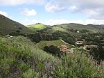
Las Garzas Creek is a 9.0-mile-long (14.5 km) northeastward-flowing stream, the lowermost major tributary of the Carmel River. It originates about 1.2 miles (1.9 km) southeast of Palo Corona summit on a saddle between Patriarch Ridge and an unnamed peak to its south. This saddle is part of the east-west watershed divide of the northern Santa Lucia Range. The creek flows almost entirely through the Santa Lucia Preserve to its confluence with the Carmel River in Carmel Valley, Monterey County, California.
Excerpt from the Wikipedia article Las Garzas Creek (Carmel River tributary) (License: CC BY-SA 3.0, Authors, Images).Las Garzas Creek (Carmel River tributary)
Aliso Road,
Geographical coordinates (GPS) Address Nearby Places Show on map
Geographical coordinates (GPS)
| Latitude | Longitude |
|---|---|
| N 36.492222222222 ° | E -121.75111111111 ° |
Address
Aliso Road
California, United States
Open on Google Maps


