Rancho Los Laureles
California ranchosCarmel Valley, CaliforniaRanchos of Monterey County, California
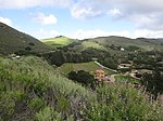
Rancho Los Laureles was a 6,625-acre (26.81 km2) Mexican land grant in present-day Monterey County, California given in 1839 by Governor Juan Alvarado to José Manuel Boronda and Vicente Blas Martínez. Los Laureles refers to the California Bay Laurel tree. The grant extended along the Carmel River and the Carmel Valley, was bounded to the east by the Rancho Tularcitos and Rancho Los Laureles (Ransom) on the west, and encompasses present day Carmel Valley Village.
Excerpt from the Wikipedia article Rancho Los Laureles (License: CC BY-SA 3.0, Authors).Rancho Los Laureles
Via Los Zorros,
Geographical coordinates (GPS) Address Nearby Places Show on map
Geographical coordinates (GPS)
| Latitude | Longitude |
|---|---|
| N 36.5 ° | E -121.75 ° |
Address
Via Los Zorros
California, United States
Open on Google Maps


