High Hoyland

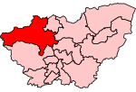
High Hoyland is a village and civil parish in the Metropolitan Borough of Barnsley in South Yorkshire, England, on the border with West Yorkshire. It lies to the west of Kexbrough, and is located at approximately 53°35′10″N 1°35′30″W, at an elevation of around 200 metres above sea level. At the 2001 census it had a population of 142, reducing to 128 at the 2011 Census.There are many Hoylands in Barnsley - there is the village of Hoyland itself south east of Barnsley on the road to Sheffield, which includes the former hamlets of Hoyland Common, Upper Hoyland and Hoyland Nether (nether being old English for "lower"). Hoylandswaine is located on the opposite side of the wide valley, and at almost 1000 feet above sea level has a wilder and bleaker feel than High Hoyland. The word Hoyland is derived from Norse, and at its simplest means "farm on a hill". Despite there being countless farms on hills around England, the majority of the Hoylands are concentrated in Barnsley.
Excerpt from the Wikipedia article High Hoyland (License: CC BY-SA 3.0, Authors, Images).High Hoyland
Geographical coordinates (GPS) Address Nearby Places Show on map
Geographical coordinates (GPS)
| Latitude | Longitude |
|---|---|
| N 53.58 ° | E -1.58 ° |
Address
Tivy Dale
S75 4AA
England, United Kingdom
Open on Google Maps


