place

Government Centre station

1989 establishments in AlbertaCapital LineEdmonton Light Rail Transit stationsEdmonton Transit Service transit centresMetro Line
Pages with no open date in Infobox stationRailway stations in Canada opened in 1989Railway stations located underground in CanadaUse Canadian English from May 2013
Grandin LRT Station 2019

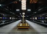
Government Centre station (formerly known as Grandin/Government Centre station) is an Edmonton Light Rail Transit station in Edmonton, Alberta, Canada. It serves both the Capital Line and the Metro Line. It is an underground station located beneath 110 Street between 99 Avenue and 98 Avenue. The station provides service to the Government Centre part of the downtown core and the neighbourhood of Oliver. The station is connected to the Alberta Legislature Building and several other government buildings by underground walkways of the Edmonton Pedway.

Excerpt from the Wikipedia article Government Centre station (License: CC BY-SA 3.0, Authors, Images).

Government Centre station
110 Street NW, Edmonton Central Core

Geographical coordinates (GPS) Address Nearby Places
placeShow on map

Wikipedia: Government Centre stationContinue reading on Wikipedia

Geographical coordinates (GPS)

Latitude Longitude
N 53.536111111111 ° E -113.51027777778 °
placeShow on map

Address

Government Centre

110 Street NW
T5K 1J7 Edmonton, Central Core
Alberta, Canada
mapOpen on Google Maps

Grandin LRT Station 2019
Share experience

Nearby Places

Fort Edmonton

Fort Edmonton (also named Edmonton House) was the name of a series of trading posts of the Hudson's Bay Company (HBC) from 1795 to 1914, all of which were located on the north banks of the North Saskatchewan River in what is now central Alberta, Canada. It was one of the last points on the Carlton Trail, the main overland route for Metis freighters between the Red River Colony and the points west and was an important stop on the York Factory Express route between London, via Hudson Bay, and Fort Vancouver in the Columbia District. It also was a connection to the Great Northland, as it was situated relatively close to the Athabasca River whose waters flow into the Mackenzie River and the Arctic Ocean. Located on the farthest north of the major rivers flowing to the Hudson Bay and the HBC's shipping posts there, Edmonton was for a time the southernmost of the HBC's forts. From 1795 to 1830 it was located in four successive locations. Prior to 1821 each location was paired with a Fort Augustus of the North West Company (NWC). The fifth and final Fort Edmonton, 1830–1914, was the one that evolved into present-day Edmonton. Fort Edmonton was also called Fort-des-Prairies, by French-Canadians trappers and coureurs des bois, and amiskwaskahegan or "Beaver Hills House" in Cree, the most spoken Indigenous language in the region during the 19th century.In the late 18th century, the HBC, established in 1670, was in fierce competition with the NWC for the trade of animal furs in Rupert's Land. As one company established a fur trading post, the other would counter by building its post in close proximity or even farther upstream. Expansion up the Saskatchewan River was heated in the 1790s.

High Level Bridge Streetcar

The High Level Bridge Streetcar is a historic streetcar ride over the High Level Bridge in Edmonton, Alberta. It travels from the Strathcona Streetcar Barn & Museum, just north of the Strathcona Farmers Market, in Old Strathcona, to Jasper Plaza south of Jasper Avenue, between 109 Street and 110 Street, in downtown, with three intermediate stops. It operates between the Victoria Day weekend in May, and Thanksgiving weekend in October. It is operated by the Edmonton Radial Railway Society, which operates five more streetcars on a second line in the river valley at Fort Edmonton Park. Starting from a new terminus at Whyte Ave, the streetcar continues to the Strathcona Streetcar Barn & Museum, but only stop there when traveling north. From there, it travels on the former Canadian Pacific (CP) Rail line in a north west direction. It first passes the Calgary & Edmonton Railway Station Museum at present-day 105 Street; this is a replica of the station that was the northern anchor of the Calgary and Edmonton Railway from 1891 to 1908. After a level crossing stop at 107 Street, the streetcar goes under the Saskatchewan Drive, 109 Street, and Walterdale Hill intersection. While turning north, the middle stop is in the neighbourhood of Garneau at 90 Avenue, before getting on the High Level Bridge. After travelling high over the surface of the North Saskatchewan River, it continues over River Valley Road, and 97 Avenue, entering the Ribbon of Steel multi-use corridor. The Ribbon of Steel is a corridor designated by Alberta Infrastructure and the City of Edmonton for the preservation of streetcar rail in Edmonton, and to provide a running/cycling path between 109 Street and 110 Street, from 97 Avenue to Jasper Avenue. The first stop on the Ribbon of Steel is the Government Centre stop, with walking access to the Government Centre station, and the Legislature grounds. The northern terminus of the High Level Bridge Streetcar ride is at Jasper Plaza, just south of Jasper Avenue. The streetcar system that existed in Edmonton until 1951 ran through the downtown core, including down Jasper Avenue. The former rail line continued north, where 110 Street is now, to the Old Canadian National rail yard (north of 104 Avenue). The new Whyte Ave terminus opened on May 19, 2022, after the ERRS spent more than ten years working with other stakeholders to plan and construct the 800-metre extension. To do this, the rail crossing on Gateway Boulevard was reconstructed, after originally being removed in order to keep freight trains away from the streetcars when CP stopped running trains north of Whyte Ave. During summer festivals, such as the Fringe, service is extended to accommodate the increase in crowds.