place

Salmon River (Lincoln County, Oregon)

Oregon Coast RangeRivers of Lincoln County, OregonRivers of OregonRivers of Polk County, OregonRivers of Tillamook County, Oregon
SalmonriverOR
SalmonriverOR

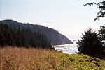
The Salmon River flows from the Central Oregon Coast Range to the Pacific Ocean coast of northwest Oregon in the United States. About 24 miles (39 km) long, it begins and ends in Lincoln County but also flows briefly through western Polk and southern Tillamook counties. Much of its course lies within the Siuslaw National Forest.Rising in the mountains near the Lincoln–Polk county line, it flows east into Polk County, then north and west, re-entering Lincoln County, entering Tillamook County and re-entering Lincoln County near Oregon Route 18. It continues generally west-southwestward through the Siuslaw National Forest, turning west again to enter the Pacific near Cascade Head, about 4 miles (6 km) north of Lincoln City.Following the river through the mountains, Route 18 connects to Sheridan, McMinnville and the South Yamhill River valley to the east and U.S. Route 101 to the west. The river and highway pass through the Van Duzer Forest Corridor State Wayside. The river supports populations of wild steelhead and coastal cutthroat trout, as well as chinook and coho salmon released each year from a hatchery at Otis.

Excerpt from the Wikipedia article Salmon River (Lincoln County, Oregon) (License: CC BY-SA 3.0, Authors, Images).

Salmon River (Lincoln County, Oregon)
Savage Road,

Geographical coordinates (GPS) Address Nearby Places
placeShow on map

Wikipedia: Salmon River (Lincoln County, Oregon)Continue reading on Wikipedia

Geographical coordinates (GPS)

Latitude Longitude
N 45.046666666667 ° E -124.00611111111 °
placeShow on map

Address

Savage Road

Savage Road

Oregon, United States
mapOpen on Google Maps

SalmonriverOR
SalmonriverOR
Share experience

Nearby Places

Cascadia subduction zone

The Cascadia subduction zone is a 960 km (600 mi) fault at a convergent plate boundary, about 112-160 km (70-100 mi) off the Pacific Shore, that stretches from northern Vancouver Island in Canada to Northern California in the United States. It is capable of producing 9.0+ magnitude earthquakes and tsunamis that could reach 30m (100 ft). The Oregon Department of Emergency Management estimates shaking would last 5-7 minutes along the coast, with strength and intensity decreasing further from the epicenter. It is a very long, sloping subduction zone where the Explorer, Juan de Fuca, and Gorda plates move to the east and slide below the much larger mostly continental North American Plate. The zone varies in width and lies offshore beginning near Cape Mendocino, Northern California, passing through Oregon and Washington, and terminating at about Vancouver Island in British Columbia.The Explorer, Juan de Fuca, and Gorda plates are some of the remnants of the vast ancient Farallon Plate which is now mostly subducted under the North American Plate. The North American Plate itself is moving slowly in a generally southwest direction, sliding over the smaller plates as well as the huge oceanic Pacific Plate (which is moving in a northwest direction) in other locations such as the San Andreas Fault in central and southern California. Tectonic processes active in the Cascadia subduction zone region include accretion, subduction, deep earthquakes, and active volcanism of the Cascades. This volcanism has included such notable eruptions as Mount Mazama (Crater Lake) about 7,500 years ago, the Mount Meager massif (Bridge River Vent) about 2,350 years ago, and Mount St. Helens in 1980. Major cities affected by a disturbance in this subduction zone include Vancouver and Victoria, British Columbia; Seattle, Washington; and Portland, Oregon.

Pixieland (Oregon)

Pixieland was an amusement park near Otis Junction, Oregon, United States, located about three miles (5 km) north of Lincoln City. Opened in 1969, it operated for only four years.The name and theme of the park came from nearby Lincoln City. A popular restaurant there was named Pixie Kitchen, which opened in 1930 and had the slogan "Heavenly Food on the Oregon Coast". Jerry Parks and his wife Lu Parks ran Pixie Kitchen and announced in 1967 the vision of Pixieland as a 57-acre (230,000 m2) "Fairytale Story of Oregon."The park opened on June 28, 1969 with a dedication from Governor Tom McCall to the "families of Oregon". More than $800,000 was invested, including two public stock offerings. Pixieland hired two former Disneyland employees: the director of music and director of special promotions.Rides included a 2 ft (610 mm) narrow gauge train called Little Toot (later renamed Little Pixie) and a log flume. Entertainment was found at the Blue Bell Opera House where melodramas were performed. Other buildings and attractions included the Main Street Arcade, the Print Shop, The Shootout, and the Darigold Cheese Barn. Eating places included Fisher Scones and Franz Bread Rest Hut.A 1975 headline in the Oregon Journal declared "Pixieland Dream Goes 'Poof!': Dreams of a multimillion dollar fantasy world shattered into a fiscal nightmare." After the park closed, the rides were sold and the buildings demolished. The Little Pixie (renamed Merriweather) and log flume rides were sold to Lagoon amusement park where they still operate today. For several decades, the Pixieland site was an RV park which transitioned into a trailer home park. Today, a tide-gate house with a pink painted roof is the only trace of Pixieland.Since the early 1980s, Siuslaw National Forest has been under mandate to restore the Salmon River estuary conditions which development of Pixieland partially disrupted with creek diversions and dikes. The site is now being transformed back into its original wetland state.