place

Marcy-Holmes, Minneapolis

AC with 0 elementsMinnesota populated places on the Mississippi RiverNeighborhoods in Minneapolis
MinneapolisMarcyHolmesNeighborhood

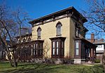
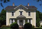
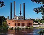
Marcy-Holmes is the first neighborhood of Minneapolis. The majority of the community is residential and sits upon a bluff overlooking the river and the city skyline. However, a small section of the neighborhood along the river is an industrial zone.It is bordered on the south by the Mississippi River, to the east by the University of Minnesota and 15th Avenue SE, to the north by the railroad tracks that separate it from the Como Neighborhood, and to the west by Central Avenue. Although somewhat confusing to newcomers, the Marcy-Holmes neighborhood is considered part of Southeast Minneapolis, despite its seemingly centralized location within the city today. Every street and avenue within the neighborhood is labeled "SE"- South of East Hennepin Avenue and East of the Mississippi River. Entirely within Minneapolis' Ward 3, Marcy-Holmes is represented by City Council member Steve Fletcher. The neighborhood is named after Marcy Park and Holmes Park (themselves named in honor of William L. Marcy and Oliver Wendell Holmes[1]) which are located within the neighborhood. Marcy-Holmes is well known for its diverse community, its commercial districts, St. Anthony Main and Dinkytown, and its immediate proximity to the East Bank of the University of Minnesota-Twin Cities campus.

Excerpt from the Wikipedia article Marcy-Holmes, Minneapolis (License: CC BY-SA 3.0, Authors, Images).

Marcy-Holmes, Minneapolis
Southeast University Avenue, Minneapolis

Geographical coordinates (GPS) Address Phone number Website Nearby Places
placeShow on map

Wikipedia: Marcy-Holmes, MinneapolisContinue reading on Wikipedia

Geographical coordinates (GPS)

Latitude Longitude
N 44.9841 ° E -93.2481 °
placeShow on map

Address

Alma

Southeast University Avenue 528
55414 Minneapolis
Minnesota, United States
mapOpen on Google Maps

Phone number

call+16123794909

Website
almampls.com

linkVisit website

MinneapolisMarcyHolmesNeighborhood
Share experience

Nearby Places

Northeast, Minneapolis

Northeast is a defined community in the U.S. city of Minneapolis that is composed of 13 smaller neighborhoods whose street addresses end in "NE". Unofficially it also includes the neighborhoods of the University community which have "NE" addresses, and the entirety of the Old Saint Anthony business district, which sits on the dividing line of "NE" and "SE" addresses. In the wider community, this business district, which is the oldest settlement in the city, is often identified as the heart of Northeast, in part because it lies across the Mississippi River from Downtown Minneapolis. Northeast is sometimes referred to as "Nordeast", reflecting the history of northern and eastern European immigrants and their language influence. The modern community includes commercial districts stretching along the major corridors of University Avenue, Central Avenue, East Hennepin Avenue, Broadway Street, and Stinson and New Brighton Boulevards towards the city limits. Blending a heritage of old architecture, classic housing, bustling commercial streets, and industrial work centers, along with new residential high-rises, suburban cul-de-sacs, big-box retail, and a popular art scene, Northeast offers diverse amenities as part bedroom neighborhood and job center for the city of Minneapolis. The prominent features of Northeast include ornate Eastern European influenced churches and massive grain silos and mills. Mostly built around the late 19th to early 20th century, these structures shadow the landscape of modest Victorians and four story apartments. The area was the City of St. Anthony before it was annexed into Minneapolis, and is thus sometimes confused with the city named Saint Anthony which abuts Northeast Minneapolis on the northeast, or Saint Anthony Park, a Saint Paul neighborhood that abuts it to the northeast.