place

Mauldslie Bridge

1861 establishments in ScotlandBridges across the River ClydeBridges completed in 1861Category A listed buildings in South LanarkshireScottish building and structure stubs
Stone bridgesUse British English from March 2022
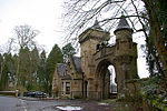
Mauldslie Bridge Facing Mauldslie West Lodge geograph.org.uk 759915

Mauldslie Bridge is a three-segmental-arch bridge in Dalserf, South Lanarkshire, Scotland. It crosses the River Clyde between the A72 road and the former location of Mauldslie Castle. Built in 1861, and now a Category A listed structure, the bridge is believed to be the work of David Bryce. Mauldslie Castle West Lodge and archway stands at the western end of the bridge. They are listed separately at Historic Environment Scotland.The bridge was built for James Hozier, 2nd Baron Newlands, to serve Mauldslie Castle, built by the Thomas, 5th Earl of Hyndford, in 1793. The castle was demolished in 1935. A seated-dog motif above the gate, which appears with an inscription of "Aye Ready", can also be found in the garden of the Marna gate lodge, to the south. That also is a listed structure.Winston Churchill has crossed the bridge, to attend gatherings of Scottish gentry.Repairs began on the bridge in 2019, with the hope of preserving it for future generations.

Excerpt from the Wikipedia article Mauldslie Bridge (License: CC BY-SA 3.0, Authors, Images).

Mauldslie Bridge
Mauldslie Bridge,

Geographical coordinates (GPS) Address Nearby Places
placeShow on map

Wikipedia: Mauldslie BridgeContinue reading on Wikipedia

Geographical coordinates (GPS)

Latitude Longitude
N 55.730784 ° E -3.90671 °
placeShow on map

Address

Mauldslie Bridge

Mauldslie Bridge
ML8 5QD
Scotland, United Kingdom
mapOpen on Google Maps

Mauldslie Bridge Facing Mauldslie West Lodge geograph.org.uk 759915
Share experience

Nearby Places

Edinburgh the Walk
Edinburgh the Walk

Edinburgh the Walk (stylized Edinburgh THE WALK), is a guidebook by Roddy McDougall and Elizabeth May. It describes a long-distance footpath linking the parks, green spaces and hills of Scotland's capital city. The book outlines a 69 kilometres (43 mi) long route which is divided into eight sections. While not currently waymarked, it follows parts of several long-established walking routes in the city - John Muir Way, Water of Leith Walkway, River Almond, Lothian Walkway as well as paths created from the city's former railway lines. It is intended to be for Edinburgh what the Capital Ring is for London - a walking route which leads through different parts of the city which might not otherwise be visited. The book highlights the geology, architecture and arts of Edinburgh beyond its better-known centre including some of those who have contributed to the city's history - novelist and poet Sir Walter Scott, geologist and writer Hugh Miller, geologist James Hutton and the Duke of Buccleuch. The route starts at Edinburgh Castle and heads north east towards the port of Leith before going alongside the southern shore of the Firth of Forth. From there it turns inland at Cramond and heads south over Corstorphine Hill towards Craiglockhart Hill.The route then takes in the summits of Braid Hills and Blackford Hill before heading towards Craigmillar Castle. It then leads north towards the seaside resort of Portobello, Edinburgh before climbing up to the city's highest point, the extinct volcano Arthur's Seat. The route ends at the gates to Holyrood Palace beside the Scottish Parliament Building. Travel-writer Richard Franks completed the whole walk in three and a half days. The route was also featured on 'Out of Doors' on BBC Radio Scotland in August 2022. Each section of the route begins and ends with access to public transport.