place

Leinola

Districts of TampereWestern Finland Province geography stubs
Sign panoramio roadmap

Leinola is a district in the eastern part of Tampere, Finland. The neighboring parts of the city are Linnainmaa and Holvasti. Leinola School is located in the Leinola district. The area is served by bus lines 1, 8 and 38 of the Tampere City Transport. The southern boundary of the district is the Tampere–Haapamäki railway. There is also a statue of Marshal Mannerheim in Leinola.Leinola was mentioned in the 1540 land register as a village belonging to the parish of Messukylä, with five houses. The owner of three of these houses had the same nickname Leinoij in the 1553 land register. Messukylä was annexed to the city of Tampere in 1947, and the first town plan for the Leinola area was confirmed in 1952.The area's street names includes both Kalevala-themed and canine-themed nomenclatures, the latter based on the old place called Koiramäki ("dog hill"). Instead, the street names Lukinkatu, Mikkolankatu and Vestonkatu refer to old main buildings of the historical village. The name of Karjumäenkatu is based on Karjumäki ("boar hill"), located north of the street, which was once used as a pig pasture. The Pulkkisenkatu and Pulkkisenraitti are both named after Pulkkisenmäki, and the Pulkkinen's smokehouse is remembered as the last in the area.

Excerpt from the Wikipedia article Leinola (License: CC BY-SA 3.0, Authors, Images).

Leinola
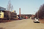
Mikkolankatu, Tampere Leinola (Koillinen suuralue)

Geographical coordinates (GPS) Address Nearby Places
placeShow on map

Wikipedia: LeinolaContinue reading on Wikipedia

Geographical coordinates (GPS)

Latitude Longitude
N 61.48465015 ° E 23.905547230556 °
placeShow on map

Address

Mikkolankatu 4
33730 Tampere, Leinola (Koillinen suuralue)
Finland
mapOpen on Google Maps

Sign panoramio roadmap
Share experience

Nearby Places

Ristinarkku
Ristinarkku

Ristinarkku (Finnish pronunciation: [ˈristinˌɑrkːu]) is a district in Tampere, Finland. The district also includes the Janka's residential area. There are a school and several retail stores in the area. The area is close to the city center and has apartment buildings as well as townhouses. The Sampo Highway runs through Ristinarkku, and the district is bordered on the south by the Tampere–Haapamäki railway and on the east by the eastern part of the Tampere Ring Road (Highway 9). The neighboring parts of the city are Hakametsä, Huikas, Takahuhti, Pappila, Linnainmaa, Hankkio and Messukylä.The Ristinarkku area was the center of the village of Takahuhti, which belonged to Messukylä, where most of the village's houses were still built in the late 19th century as a dense group. The rest of the name Ristinarkku is most likely based on the word orko, which means a meadow or field cleared of drooping. Professor Viljo Nissilä has speculated that a surveyor who has not had local knowledge has written the word orko in what he thinks is a more understandable form of arkku (meaning "coffin"). Thus, the original name Ristinorko, which would have meant the field cleared next to the road junction and gradually also the junction, would have changed into Ristinarkku (literally meaning the "coffing of cross") with a similar phonetic status in the Finnish language. On the other hand, the word arkku is also ambiguous, as it can refer to, for example, a coffin or a bridge support. The roots of the name may date back to the 13th century, as the medieval settlement of Takahuhti had become a group village by the 14th century at the latest. The first town plan of Ristinarkku was confirmed in the 1950s.The name of the Vehnämyllynkatu street is based on the wheat mill located in Ristinarkku, built in the late 19th century. The mill was demolished in connection with the construction of a street bridge across the railway in 1957.