place

Nurmi (district)

Districts of TampereWestern Finland Province geography stubs
Christian School Tampere

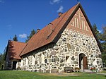
Nurmi is a statistical area of Tampere, Finland, located about ten kilometers northeast of the city center. Nurmi is bordered on the west by Lake Näsijärvi, on the east by the Kangasala town, on the south by Olkahinen and on the north by Sorila and Aitoniemi. At the end of 2014, Nurmi had 360 inhabitants. Until 1965, Nurmi belonged to the municipality of Aitolahti before the municipality was incorporated into Tampere. Initially, Nurmi also formed its own urban area, but today it has merged into the Tampere urban area. The Tampere Christian School is located in Nurmi. It operates on a co-Christian basis and is maintained by the Adventist Church of Finland, offering free basic education based on Christian basic values and outlook on life for all grades of primary school.

Excerpt from the Wikipedia article Nurmi (district) (License: CC BY-SA 3.0, Authors, Images).

Nurmi (district)
Nurmintie, Tampere Nurmi (Pohjoinen suuralue)

Geographical coordinates (GPS) Address Nearby Places
placeShow on map

Wikipedia: Nurmi (district)Continue reading on Wikipedia

Geographical coordinates (GPS)

Latitude Longitude
N 61.541666666667 ° E 23.927777777778 °
placeShow on map

Address

Nurmintie

Nurmintie
33610 Tampere, Nurmi (Pohjoinen suuralue)
Finland
mapOpen on Google Maps

Christian School Tampere
Share experience

Nearby Places

Aitolahti
Aitolahti

Aitolahti (Finnish pronunciation: [ˈɑi̯tolɑhti]; now forms the Tampere subdivision under the name Aito) is a former municipality in Pirkanmaa region, Finland. It was consolidated in 1966 with Tampere, and at the same time Tampere got new districts: Sorila, Nurmi and Aitoniemi. Until 1947, the neighboring municipalities of Aitolahti included Messukylä, which was consolidated with the city of Tampere. Highway 9 (E63) between Tampere and Jyväskylä and the regional road 338 between Tampere and Ruovesi pass through Aitolahti. The old Aitolahti municipal center was Sorila. The densest population is in the southern parts of the region, in the districts of Olkahinen and Nurmi. The highest terrain in Aitolahti is Aitovuori, located near the border of Kangasala, extending 179 meters above sea level and more than 80 meters above Lake Näsijärvi. When the Aitolahti became independent parish after leaving Messukylä, there were only about 600 inhabitants, and the population grew very slowly for a long time, until growth accelerated in the 1950s.At the end of the 19th century, the Finnish geologist J. J. Sederholm discovered oval-shaped depressions in the shore cliffs and rocks of Lake Näsijärvi, which he called Corycium enigmaticum, "enigmatic carbon bags". These are remnants of rudimentary microbial activity about two billion years ago and have been found in the rest of the world only in South Africa and Canada. The site was designated a nature reserve in 1962. These 2 to 30-centimeter-long "carbon bags" are also found on the opposite shore of Lake Näsijärvi on the Ylöjärvi side. These carbon bags also gave their subject in 1965, in the last year of the municipality's independence, the coat of arms of the municipality of Aitolahti, drawn by Gustaf von Numers.In the 1980s, pork soup and barley groat porridge with buttermilk were named traditional dishes of Aitolahti parish.

Ristinarkku
Ristinarkku

Ristinarkku (Finnish pronunciation: [ˈristinˌɑrkːu]) is a district in Tampere, Finland. The district also includes the Janka's residential area. There are a school and several retail stores in the area. The area is close to the city center and has apartment buildings as well as townhouses. The Sampo Highway runs through Ristinarkku, and the district is bordered on the south by the Tampere–Haapamäki railway and on the east by the eastern part of the Tampere Ring Road (Highway 9). The neighboring parts of the city are Hakametsä, Huikas, Takahuhti, Pappila, Linnainmaa, Hankkio and Messukylä.The Ristinarkku area was the center of the village of Takahuhti, which belonged to Messukylä, where most of the village's houses were still built in the late 19th century as a dense group. The rest of the name Ristinarkku is most likely based on the word orko, which means a meadow or field cleared of drooping. Professor Viljo Nissilä has speculated that a surveyor who has not had local knowledge has written the word orko in what he thinks is a more understandable form of arkku (meaning "coffin"). Thus, the original name Ristinorko, which would have meant the field cleared next to the road junction and gradually also the junction, would have changed into Ristinarkku (literally meaning the "coffing of cross") with a similar phonetic status in the Finnish language. On the other hand, the word arkku is also ambiguous, as it can refer to, for example, a coffin or a bridge support. The roots of the name may date back to the 13th century, as the medieval settlement of Takahuhti had become a group village by the 14th century at the latest. The first town plan of Ristinarkku was confirmed in the 1950s.The name of the Vehnämyllynkatu street is based on the wheat mill located in Ristinarkku, built in the late 19th century. The mill was demolished in connection with the construction of a street bridge across the railway in 1957.