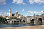
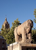
The Roman bridge of Salamanca (in Spanish: Puente romano de Salamanca), also known as Puente Mayor del Tormes, is a Roman bridge crossing the Tormes River on the banks of the city of Salamanca, in Castile and León, Spain. The importance of the bridge as a symbol of the city can be seen in the first quartering of city's coat of arms (along with its stone bull-verraco). It has been known traditionally as puente mayor and as puente prinçipal (main bridge) which gives access to the southern part of the city. The bridge as it currently appears is a result of several restorations. One of the disasters that most affected it was the Flood of San Policarpo on the night of January 26, 1626. It was declared Artistic Historic Monument on June 3, 1931, and Bien de Interés Cultural in 1998. Until the beginning of 20th century it carried the main road into the city, and continued to bear heavy traffic until 1973. Since the construction of a third bridge for road traffic it remains exclusive for pedestrians.
The bridge is actually a construction of two bridges separated by a central fortification: the old bridge which extends along the portion near the city is of Roman origin, and the new bridge. Of the twenty-six arches, only the first fifteen date from Roman times. The stone used in its construction differs in origin, while employed in Roman bridge area is originally from the granite quarries of Los Santos (Béjar), the stone used in the hispana part and more modern bridge, comes from the area of Ledesma. The bridge has been restored on numerous occasions and has survived several attempts at demolition. Many of the restorations have been poorly documented, leaving for the study of archaeologists a great part of the work of determination, dating and explaining the ancient construction techniques. The date of the construction of the bridge is not precisely known, but is among the mandates of the Emperors Augustus (27 B. C.-14 D. C.) and Vespasian (69-79), making it a bimillennium architectural monument.


