place

Northern Pegasus Bay

Parks in Canterbury, New ZealandProtected areas of Canterbury, New ZealandRegional parks of New ZealandTourist attractions in Canterbury, New ZealandWaimakariri District
Pegasus Bay, with New Brighton the spit in the foreground

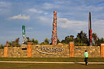
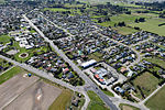
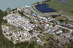
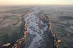
Northern Pegasus Bay is a regional park in the northern part of Canterbury's Pegasus Bay in New Zealand's South Island. It is operated by Environment Canterbury.The regional park covers an area north of Waimakariri River , including the beaches in Kairaki, The Pines Beach, Woodend, Waikuku, Leithfield, Amberley and Ashley River / Rakahuri estuary.

Excerpt from the Wikipedia article Northern Pegasus Bay (License: CC BY-SA 3.0, Authors, Images).

Northern Pegasus Bay
Gladstone Road,

Geographical coordinates (GPS) Address Nearby Places
placeShow on map

Wikipedia: Northern Pegasus BayContinue reading on Wikipedia

Geographical coordinates (GPS)

Latitude Longitude
N -43.3259565 ° E 172.6956407 °
placeShow on map

Address

Gladstone Road
7612
Canterbury, New Zealand
mapOpen on Google Maps

Pegasus Bay, with New Brighton the spit in the foreground
Share experience

Nearby Places

Kaiapoi
Kaiapoi

Kaiapoi is a town in the Waimakariri District of the Canterbury region, in the South Island of New Zealand. The town is located approximately 17 kilometres north of central Christchurch, close to the mouth of the Waimakariri River. It is considered a satellite town of Christchurch and is part of the Christchurch functional urban area.Kaiapoi is known for its substantial precolonial pā, Te Kōhaka-a-kaikai-a-waro, established by powerful Kāi Tahu nobleman Tūrākautahi. One of the sons of the powerful rangatira Tūāhuriri, Tūrākautahi exerted vast influence over historical Ōtautahi (the site of modern-day Christchurch). His family controlled the pā he established in the area until it was sacked in 1831 by Te Rauparaha and his followers. The pā was one of the greatest centre of knowledge, economics and natural resources, with a highly complex social structure. All decisions were undertaken by the nobility, who consulted with highly skilled tohunga. In selecting the pā site, Tūrākautahi determined that food (kai) would need to be poi ("swung in"- swung over the pā's protective walls via rope, and also because it lay in the middle of a swamp) from other places. This is how Kaiapoi got its name, and can translated as a metaphor for "economics"Kaiapoi suffered extensive damage in the 2010 Canterbury and also the February 2011 Christchurch earthquakes, which rendered many homes uninhabitable and businesses inoperable. Large areas were condemned as part of a residential red zone covering uninhabitable areas.