place

Waikuku

Populated places in Canterbury, New ZealandUse New Zealand English from December 2015Waimakariri District
Waikuku Methodist Church (15484640762)

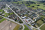
Waikuku is a small town in the Canterbury region of New Zealand, which sits 28 km north of central Christchurch. Waikuku lies 11.8 km (7.3 mi) south of Leithfield on state highway 1 and 3 km (1.9 mi) north of Woodend. In 1901 there were 86 people resident in Waikuku according to that year's census. Waikuku settlement had a population of 156 people at the time of the 2018 Census. It is popular with both those that commute into work in Christchurch each day and with owners of holiday houses. Waikuku was home to rope and twine works. This business started off using flax from local swamps. It closed in 1987. The nearby sandy beach and pine forests are popular with surfers, swimmers, campers and horse-riders, and the large estuary of the Ashley River hosts many species of birds.Just south of Waikuku, on Preeces Road, are the remains of the Kaiapoi Pa, an important trading centre for Ngāi Tahu in the 18th century.

Excerpt from the Wikipedia article Waikuku (License: CC BY-SA 3.0, Authors, Images).

Waikuku
Main North Road,

Geographical coordinates (GPS) Address Nearby Places
placeShow on map

Wikipedia: WaikukuContinue reading on Wikipedia

Geographical coordinates (GPS)

Latitude Longitude
N -43.292 ° E 172.685 °
placeShow on map

Address

Main North Road 1455
7648
Canterbury, New Zealand
mapOpen on Google Maps

Waikuku Methodist Church (15484640762)
Share experience

Nearby Places

Kaiapoi
Kaiapoi

Kaiapoi is a town in the Waimakariri District of the Canterbury region, in the South Island of New Zealand. The town is located approximately 17 kilometres north of central Christchurch, close to the mouth of the Waimakariri River. It is considered a satellite town of Christchurch and is part of the Christchurch functional urban area.Kaiapoi is known for its substantial precolonial pā, Te Kōhaka-a-kaikai-a-waro, established by powerful Kāi Tahu nobleman Tūrākautahi. One of the sons of the powerful rangatira Tūāhuriri, Tūrākautahi exerted vast influence over historical Ōtautahi (the site of modern-day Christchurch). His family controlled the pā he established in the area until it was sacked in 1831 by Te Rauparaha and his followers. The pā was one of the greatest centre of knowledge, economics and natural resources, with a highly complex social structure. All decisions were undertaken by the nobility, who consulted with highly skilled tohunga. In selecting the pā site, Tūrākautahi determined that food (kai) would need to be poi ("swung in"- swung over the pā's protective walls via rope, and also because it lay in the middle of a swamp) from other places. This is how Kaiapoi got its name, and can translated as a metaphor for "economics"Kaiapoi suffered extensive damage in the 2010 Canterbury and also the February 2011 Christchurch earthquakes, which rendered many homes uninhabitable and businesses inoperable. Large areas were condemned as part of a residential red zone covering uninhabitable areas.