Buresø
Allerød MunicipalityEgedal MunicipalityFrederikssund MunicipalityLakes of ZealandLakes of the Øresund Region

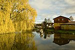
Buresø is a lake located in a tunnel valley, immediately southeast of Slangerup, where Allerød, Frederikssund and Egedal municipalities meet. The tunnel valley, which was formed during the last ice age, runs in an east-west direction and can be followed along Mølleåen all the way to the Øresund coast. Between Buresø and the nearby Bastrup Sø there is a watershed. Buresø drains via Græse Å to the west to Roskilde Fjord, Bastrup Sø drains to the east to Mølleåen. Buresø and surroundings is part of Naturpark Mølleåen.
Excerpt from the Wikipedia article Buresø (License: CC BY-SA 3.0, Authors, Images).Buresø
Kastanievej, Egedal Municipality
Geographical coordinates (GPS) Address Nearby Places Show on map
Geographical coordinates (GPS)
| Latitude | Longitude |
|---|---|
| N 55.825 ° | E 12.217777777778 ° |
Address
Kastanievej 4B
3550 Egedal Municipality
Capital Region of Denmark, Denmark
Open on Google Maps


