Black Brook (Chorley)
England river stubsLancashire geography stubsRivers of ChorleyRivers of LancashireWest Pennine Moors ... and 1 more
Yarrow catchment

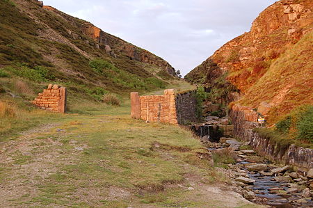
Black Brook in Lancashire has its source at Great Hill in the West Pennine Moors. The water is acidic due to a high level of peat in the uplands near to Round Loaf, giving the brook its brown colour. The young river was known as Warth Brook in olden Heapey. A feeder stream also known as Black Brook joins near Kittiwake Road - this short and weak water course commences at Eagle Tower. The jointed brook feeds Anglezarke Reservoir, and joins the River Yarrow in lowland Chorley at Yarrow Bridge. The entire course of Black Brook and the River Yarrow fall within Chorley and its villages.
Excerpt from the Wikipedia article Black Brook (Chorley) (License: CC BY-SA 3.0, Authors, Images).Black Brook (Chorley)
Belmont Road,
Geographical coordinates (GPS) Address Nearby Places Show on map
Geographical coordinates (GPS)
| Latitude | Longitude |
|---|---|
| N 53.667 ° | E -2.538 ° |
Address
Belmont Road
PR6 8DZ , Withnell
England, United Kingdom
Open on Google Maps


