Papamoa Hills Regional Park
Protected areas of the Bay of Plenty RegionWestern Bay of Plenty District

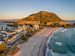
Papamoa Hills Regional Park is a protected area in the Bay of Plenty Region, owned and managed by Bay of Plenty Regional Council. It is located between Papamoa and Te Puke, on Poplar Lane off State Highway 2.It covers 135 hectares of native bush and open farmland. The landscape consists of steep hills, reaching to a summit of 224 metres with sweeping views of the Bay of Plenty coastline from the Coromandel Peninsula to East Cape.The area is a traditional home for where Papamoa’s original Māori inhabitants, including Waitaha, Ngā Pōtiki, Ngāti Pūkenga and Ngāti He. Its traditional Māori name is Te Rae o Pāpāmoa, translating roughly as "the forehead of the woman who is the hills".
Excerpt from the Wikipedia article Papamoa Hills Regional Park (License: CC BY-SA 3.0, Authors, Images).Papamoa Hills Regional Park
Poplar Lane,
Geographical coordinates (GPS) Address Nearby Places Show on map
 Continue reading on Wikipedia
 Geographical coordinates (GPS)
| Latitude | Longitude |
|---|---|
| N -37.7325 ° | E 176.2875 ° |
Address
Papamoa Hills Regional Park
Poplar Lane
3187
Bay of Plenty, New Zealand
Open on Google Maps