Saunders Lake, Oregon
Census-designated places in Coos County, OregonCensus-designated places in OregonOregon geography stubsUse mdy dates from July 2023
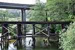
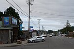
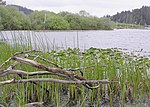
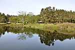
Saunders Lake is an unincorporated community and census-designated place (CDP) in Coos County, Oregon, United States. It was first listed as a CDP prior to the 2020 census.The CDP is in northwestern Coos County, along U.S. Route 101, 11 miles (18 km) north of Coos Bay and 16 miles (26 km) south of Reedsport. Saunders Lake, a small water body, is in the northern part of the CDP, draining north through Clear Lake to Saunders Creek, which flows north to Tenmile Creek between Lakeside and the Pacific Ocean. The Saunders Lake CDP is bordered to the west by the Oregon Dunes National Recreation Area.
Excerpt from the Wikipedia article Saunders Lake, Oregon (License: CC BY-SA 3.0, Authors).Saunders Lake, Oregon
Raymond Lane,
Geographical coordinates (GPS) Address Nearby Places Show on map
 Continue reading on Wikipedia
 Geographical coordinates (GPS)
| Latitude | Longitude |
|---|---|
| N 43.521111111111 ° | E -124.21055555556 ° |
Address
Raymond Lane 93767
97459
Oregon, United States
Open on Google Maps