Battle of the Nijmegen salient

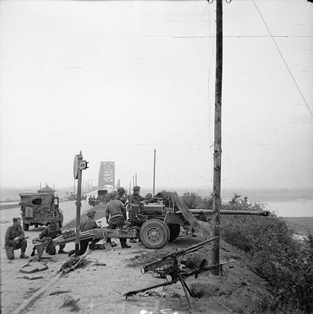
The Battle of the Nijmegen salient or the Defence of the Nijmegen bridgehead was a series of engagements that took place in the Netherlands during World War II between 30 September and 8 October 1944. The battle occurred in the aftermath of Operation Market Garden, a failed attempt by the Allies to cut off German forces in the Netherlands and end the war quickly. Walter Model who commanded German forces during Market Garden attempted to regain the Nijmegen salient which had been seized by the allies in an effort to contain the offensive and drive them off the Betuwe, which became known as 'the Island.' Wilhelm Bittrich led II SS Panzer Korps in the counter offensive, in particular with the aim of retaking Nijmegen and its bridges. German forces were not prepared to make assaults and many units were without tank support. 21st Army Group under the command of Bernard Montgomery commanded the area from Southern Holland to the North sea area. British forces on the island were led by General Ivor Thomas who commanded an ad hoc force assembled to defend the area. Despite losing some ground, the British managed to repel all the attacks. British troops then launched a counter attack from October 4, and managed to recapture all of the lost ground and gained a number of villages. The British were then reinforced by the US 101st Airborne Division and further German efforts were again defeated. When the Arnhem road bridge was destroyed by US medium bombers on October 7, sporadic fighting continued for a further three days but the Germans called off any major assault. The Germans suffered heavy casualties in infantry and tanks. 21st Army Group already committed to the defence of the salient, sent resources to open up the Scheldt estuary.
Excerpt from the Wikipedia article Battle of the Nijmegen salient (License: CC BY-SA 3.0, Authors, Images).Battle of the Nijmegen salient
Stationsstraat, Overbetuwe
Geographical coordinates (GPS) Address Nearby Places Show on map
Geographical coordinates (GPS)
| Latitude | Longitude |
|---|---|
| N 51.916666666667 ° | E 5.85 ° |
Address
Stationsstraat 16
6662 BA Overbetuwe
Gelderland, Netherlands
Open on Google Maps


