Lake Chabot
AC with 0 elementsReservoirs in Alameda County, CaliforniaReservoirs in CaliforniaReservoirs in Northern CaliforniaTourist attractions in Alameda County, California

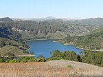
Lake Chabot is a man-made lake covering 317 acres (1.3 km2) in Alameda County, California, United States. Part of the lake lies within Oakland city limits, but most of it lies in unincorporated Castro Valley, just east of San Leandro. It was formed by the damming of San Leandro Creek. The lake was completed in 1875 to serve as a primary source of water for the East Bay. The California Office of Environmental Health Hazard Assessment (OEHHA) has developed a safe eating advisory for Lake Chabot based on levels of mercury found in fish caught here.
Excerpt from the Wikipedia article Lake Chabot (License: CC BY-SA 3.0, Authors, Images).Lake Chabot
West Shore Trail, Oakland
Geographical coordinates (GPS) Address Nearby Places Show on map
Geographical coordinates (GPS)
| Latitude | Longitude |
|---|---|
| N 37.729722222222 ° | E -122.12166666667 ° |
Address
West Shore Trail
West Shore Trail
94546 Oakland
California, United States
Open on Google Maps


