National Geographical Organization of Iran
Geographic data and information organisations in IranGeology of IranGovernment agencies of IranMinistry of Defence and Armed Forces Logistics of the Islamic Republic of IranNational mapping agencies ... and 2 more
SurveyingTechnical drawing

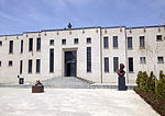
The National Geographical Organization of Iran or National Geographical Organization of the Armed Forces of Iran (Persian: سازمان جغرافیایی ایران, or Persian: سازمان جغرافیایی نیروهای مسلح) is an Iranian government agency affiliated to the Ministry of Defence and Armed Forces Logistics of Iran, which has been established to prepare quick and accurate access spatial information of the country and other areas required by the Armed Forces of Iran.
Excerpt from the Wikipedia article National Geographical Organization of Iran (License: CC BY-SA 3.0, Authors, Images).National Geographical Organization of Iran
Moalem, Tehran District 7
Geographical coordinates (GPS) Address Nearby Places Show on map
 Continue reading on Wikipedia
 Geographical coordinates (GPS)
| Latitude | Longitude |
|---|---|
| N 35.7274119 ° | E 51.4488425 ° |
Address
معلم غربی
Moalem
15697-53516 Tehran, District 7
Iran
Open on Google Maps