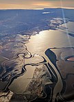
Ogilvie Island
Geography of San Jose, CaliforniaIslands of Northern CaliforniaIslands of San Francisco BayIslands of Santa Clara County, CaliforniaSanta Clara County, California geography stubs

Ogilvie Island is a patch of mud in San Francisco Bay. It within the limits of the city of San Jose, in Santa Clara County, California, and named for county planner Arthur Ogilvie. Its coordinates are 37°27′55″N 122°00′37″W, and the United States Geological Survey gave its elevation as 0 ft (0 m) in 2012. It appears on a 2012 USGS map of the area.
Excerpt from the Wikipedia article Ogilvie Island (License: CC BY-SA 3.0, Authors, Images).Ogilvie Island
Alviso Slough Trail, San Jose
Geographical coordinates (GPS) Address Nearby Places Show on map
Geographical coordinates (GPS)
| Latitude | Longitude |
|---|---|
| N 37.465277777778 ° | E -122.01027777778 ° |
Address
Alviso Slough Trail
Alviso Slough Trail
94035 San Jose (Alviso)
California, United States
Open on Google Maps


