Wheatley, South Yorkshire
Former civil parishes in South YorkshireGeography of DoncasterPopulated places in South YorkshireUse British English from October 2021

Wheatley is an inner suburb of Doncaster, in South Yorkshire, England. It lies immediately north-east of the centre of Doncaster, mostly south of the A630 dual carriageway. It is bounded to the north by the River Don, to the east by Wheatley Hills, and to the south by Intake. Until 1974 it was in the West Riding of Yorkshire. There are numerous new housing and retail developments currently under construction to the north of the A630, opposite the Wheatley Centre shopping park.
Excerpt from the Wikipedia article Wheatley, South Yorkshire (License: CC BY-SA 3.0, Authors, Images).Wheatley, South Yorkshire
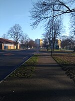
Beckett Road, Doncaster Wheatley
Geographical coordinates (GPS) Address Nearby Places Show on map
Geographical coordinates (GPS)
| Latitude | Longitude |
|---|---|
| N 53.5371 ° | E -1.1103 ° |
Address
Beckett Road
Beckett Road
DN2 4JZ Doncaster, Wheatley
England, United Kingdom
Open on Google Maps


