place

The Pulpit (Zion National Park)

Colorado PlateauLandforms of Washington County, UtahSandstone formations of the United StatesZion National Park
The Altar and the Pulpit, Zion Canyon, Zion National Park, Utah (1025444311)

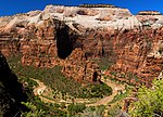
The Pulpit is a 4,600-foot (1,400 m) elevation Navajo Sandstone pillar located in Zion National Park, in Washington County of southwest Utah, United States. The Pulpit is situated in the Temple of Sinawava at the north end of Zion Canyon, rising 160 feet (49 meters) above the canyon floor and the North Fork of the Virgin River which drains precipitation runoff from this rock. It is a photographic icon seen from the parking area at the end of Zion Canyon Scenic Drive, and the entrance to The Narrows. Neighbors include Mountain of Mystery to the north, Observation Point to the southeast, Angels Landing and The Organ to the south, and Cathedral Mountain to the southwest. The first ascent was made April 15, 1967, by Fred Beckey, Eric Bjornstad, Hal Woodworth, Pat Callis, and Galen Rowell.

Excerpt from the Wikipedia article The Pulpit (Zion National Park) (License: CC BY-SA 3.0, Authors, Images).

The Pulpit (Zion National Park)
Zion Canyon Scenic Drive,

Geographical coordinates (GPS) Address Nearby Places
placeShow on map

Wikipedia: The Pulpit (Zion National Park)Continue reading on Wikipedia

Geographical coordinates (GPS)

Latitude Longitude
N 37.2838705 ° E -112.9474405 °
placeShow on map

Address

Zion Canyon Scenic Drive

Utah, United States
mapOpen on Google Maps

The Altar and the Pulpit, Zion Canyon, Zion National Park, Utah (1025444311)
Share experience

Nearby Places

Floor of the Valley Road

The Floor of the Valley Road, also known as the Zion Canyon Scenic Drive, follows the canyon of the North Fork of the Virgin River, also known as Zion Canyon, through Zion National Park, Utah, USA. A precursor to the present nine-mile road was first built in 1916, but was later redesigned by the National Park Service Branch of Plans and Designs to highlight the natural features of the valley while presenting a natural-appearing built environment. The road begins at the south boundary of the park and ends at the Temple of Sinawava. The design uses local materials such as red sandstone and rustic construction techniques according to the prevailing 1930s Park Service policy of naturalistic design. The Cable Creek Bridge is separately nominated to the National Register of Historic Places as a particularly prominent example of the style. The road surface is coated with red aggregate to continue the design theme. From the South Entrance to Canyon Junction at the mouth of Zion Canyon the road has been reconstructed and has lost many of the characteristic features of the 1930s construction. The original 1916 road, built by Park Service engineer W.O. Tufts, was a single-lane dirt road that extended as far as the Weeping Rock parking area. In 1925 a gravel-surfaced road, called the "Government Road" replaced the original road and extended all the way to the Temple of Sinawava. In 1931 and 1932 the present road was constructed on a new alignment as a Depression-era public works project. Further construction was performed from 1933 to 1942 by Civilian Conservation Corps labor.