Vaudreuil-Soulanges Regional County Municipality
Census divisions of QuebecPages with French IPAPages with non-numeric formatnum argumentsUse Canadian English from January 2023Vaudreuil-Dorion ... and 1 more
Vaudreuil-Soulanges Regional County Municipality

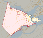
Vaudreuil-Soulanges (French pronunciation: [vodʁœj sulɑ̃ʒ]) is a regional county municipality in Quebec, Canada. It is located on a triangular peninsula in the western Montérégie region of Quebec, formed by the confluence of the Ottawa River to the north, and the St. Lawrence River to the south. Ontario is located west of here.
Excerpt from the Wikipedia article Vaudreuil-Soulanges Regional County Municipality (License: CC BY-SA 3.0, Authors, Images).Vaudreuil-Soulanges Regional County Municipality
Rue des Iris,
Geographical coordinates (GPS) Address Nearby Places Show on map
Geographical coordinates (GPS)
| Latitude | Longitude |
|---|---|
| N 45.35 ° | E -74.216666666667 ° |
Address
Rue des Iris 5
J0P 1S0
Quebec, Canada
Open on Google Maps


