place

Bumpkin Island

Boston Harbor islandsCoastal islands of MassachusettsHingham, MassachusettsIslands of Plymouth County, MassachusettsPlymouth County, Massachusetts geography stubs
Tidal islands of the United States
BumpkinIsland
BumpkinIsland

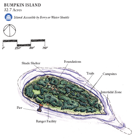
Bumpkin Island, also known as Round Island, Bomkin Island, Bumkin Island, or Ward's Island, is an island in the Hingham Bay area of the Boston Harbor. In 1902, Albert Burrage, a Boston philanthropist, had a summer hospital opened on the island for children with physical disabilities. During World War I the island was used by the U.S. Navy. Starting around 1940, the island was used as a facility for polio patients. However, the hospital closed during World War II and burned down in 1945. Since 1996, it is part of the Boston Harbor Islands National Recreation Area. The island has an area of 30 acres (120,000 m2), plus an intertidal zone of a further 31 acres (130,000 m2). It is composed of a central drumlin with an elevation of 70 feet (21 m) above sea level, surrounded by a rock-strewn shoreline. A sand spit, exposed at low tide, connects the eastern end of the island to Sunset Point in Hull.On weekends and summer weekdays, Bumpkin Island is accessible by a shuttle boat to and from Georges Island, which connects from there with ferries to Boston and Quincy.

Excerpt from the Wikipedia article Bumpkin Island (License: CC BY-SA 3.0, Authors, Images).

Bumpkin Island
Clifton Avenue,

Geographical coordinates (GPS) Address Nearby Places
placeShow on map

Wikipedia: Bumpkin IslandContinue reading on Wikipedia

Geographical coordinates (GPS)

Latitude Longitude
N 42.281111111111 ° E -70.899777777778 °
placeShow on map

Address

Clifton Avenue
02045
Massachusetts, United States
mapOpen on Google Maps

BumpkinIsland
BumpkinIsland
Share experience

Nearby Places

Slate Island
Slate Island

Slate Island is an uninhabited island of about 12.7 acres (5.1 ha) (at high tide) in Hingham Bay, an arm of Boston Harbor. It is part of Boston Harbor Islands National and State Park and is just east of Grape Island. The island mostly consists of slate outcrops partly covered with glacial till, and the shore is mostly rock. The highest elevation is 32 feet (9.8 m). The island was visited seasonally by Native Americans. In colonial times slate was quarried from the islands (the remnants of the quarry are still visible), mostly for house foundations. William Torey was given a grant for the island in 1650, with a stipulation that anyone was free to extract slate. Slate mining continued to a small degree into the 20th century and contributed to soil erosion on the rocky island. Later owners included Joseph Andrews, Samuel Lovell, Thomas Jones, and Caleb Loring. In the 17th century the island became part of the town of Hull (it is now in Weymouth). Around 1840 a hermit (his name lost to history) lived in a hut near the southern cove. (Moses Forster Sweetser opined that "his lonely hut must have made Thoreau's hermitage at Walden seem like Scollay Square after a theatre performance.") In the 1890s owner Edwin Clapp gave the island to the Clapp Memorial Association, which briefly hosted a summer camp there. Slate Island was privately owned until the 1970s when it became public property and part of the Boston Harbor Islands National and State Park. There are no trails, docks, or any other facilities on the island, which is overrun with vegetation including an abundance of poison ivy. The island is not serviced by the park ferry.

Fort Duvall
Fort Duvall

Fort Duvall was a Coast Artillery fort, part of the Harbor Defenses of Boston, in Massachusetts. What was then called Hog Island in Hull, Massachusetts was acquired by the U.S. government in 1917, and the fort was constructed in the early 1920s. It had only one gun battery, Battery Long, but it mounted the largest caliber weapons in the entire harbor defense system: a pair of 16-inch guns. These were the 16-inch gun M1919, of which only seven were deployed; 16-inch weapons deployed later were supplied by the Navy. Circa 1920 the Brewster Islands Military Reservation and the Calf Island Military Reservation were considered for a 16-inch battery; at that time a twin naval-type turret was envisioned. However, Fort Duvall was built instead.In 1922 the fort was named for Major General William Penn Duvall (1847-1920). A graduate of West Point, Duvall was born in Maryland, was a principal assistant to the Army Chief of Artillery, and served two tours of duty in the Philippines (the second as commander of all Army troops there), where he distinguished himself by his even-handed administration of the islands.The long-range guns of Fort Duvall could cover an arc running roughly from Gloucester in the north down to Plymouth in the south, and extending well out to sea. Hidden behind the bluff at Point Allerton, the fort could not be observed from the sea. Fire for the guns was directed and observed from the tall fire control tower at Point Allerton, which survives to the present (2016) under private ownership. Fort Duvall's guns were initially in open mounts, but were casemated in 1942 to protect against air attack. At the time of Battery Long's construction, the next largest guns were the barbette-mounted 12-inch guns of Battery Gardner at Fort Ruckman in Nahant, MA. Later, two more 16-inch guns were added in Nahant at Battery Murphy. A third pair of 16-inch guns was planned for Fort Dawes on Deer Island, but after the emplacements were constructed at the outset of WW2, the tubes for this battery were never delivered. Due to the emplacement of 16-inch guns, in the early 1940s many of the longer-range 10-inch and 12-inch batteries of the harbor defenses (including the batteries at Fort Revere in Hull, just north across the water from Fort Duvall), plus all of their 12-inch coast defense mortars, were decommissioned and scrapped. In 1948 Fort Duvall's guns were scrapped and the island was retained by the Army. From 1952 to 1955 a battery of four 90 mm antiaircraft guns was on the island. From 1956 to 1974 the fort was used as a Nike missile control center (B-36 C), with the launch site (B-36 L) at Webb Memorial State Park in Weymouth. In 1974 the island was turned over to the Commonwealth of Massachusetts, and was used to store school textbooks until sold to private interests for development as a gated community.

Grape Island (Massachusetts)

Grape Island is an island in the Hingham Bay area of the Boston Harbor Islands National Recreation Area. The island is part of the territory of the town of Weymouth, Massachusetts. The island has a permanent size of 54 acres (220,000 m2), plus an intertidal zone of a further 46 acres (190,000 m2), and is composed of two drumlins, reaching an elevation of 70 feet (21 m) above sea level, and connected by a marshy lowland. Tidal sand spits extend from the west end towards Weymouth Neck in Webb Memorial State Park and from the east end towards Slate Island. As a visitor attraction, Grape Island offers trails, rocky beaches, and camping in wooded campsites. At weekends and summer weekdays it is served by a shuttle boat to and from Georges Island, connecting there with ferries to Boston and Quincy.The island was farmed and grazed for three hundred years, until the 1940s. On the eve of the American Revolution, the island was owned by Hingham resident Elisha Leavitt, a Tory. In 1775, British troops raided the island during the siege of Boston, as Abigail Adams wrote to her husband John about May 24, 1775: "...it seems their Expidition (sic) was to Grape Island for Levets hay." A pitched battle ensued until the British were forced to retreat to the mainland. The angry colonists burned Leavitt's barn to the ground. In the end, very little damage was done to either side despite the effort expended. Three British soldiers may have been wounded (unconfirmed), no Continental soldiers or partisans were wounded, and less than two tons of hay were taken by the British.Since the abandonment of agricultural use in the 1940s, the natural succession of vegetation has created a wooded and shrubby landscape. Vegetation on the island includes early successional tree and shrub species on the drumlins, including staghorn sumac, gray birch, and quaking aspen. The island has an abundance of berries, including blackberry, dewberry, raspberry, blueberry, huckleberry, and American elderberry. The island's marshy lowland contains salt tolerant species such as saltspray rose, cordgrass, purple loosestrife, honeysuckle, and seaside goldenrod.Grape Island contains two freshwater springs. One spring is located on the north side of the western drumlin and is located underneath a large boulder that faces Peddock's Island. Another freshwater spring is located behind the marsh that is situated in the saddle between the two drumlins. Both of these areas are off the trail.