place

Buxton Pavilion Gardens

BuxtonGardens in DerbyshireGrade II* listed parks and gardens in DerbyshireTourist attractions in DerbyshireTourist attractions of the Peak District
Use British English from March 2020
Bandstand and Milner Bridge in Buxton Pavilion Gardens

Buxton Pavilion Gardens is a Victorian landscaped public park in the spa town of Buxton in Derbyshire. The River Wye flows through the gardens, which are a Grade II* listed public park of Special Historic Interest.

Excerpt from the Wikipedia article Buxton Pavilion Gardens (License: CC BY-SA 3.0, Authors, Images).

Buxton Pavilion Gardens
Green Lane, High Peak

Geographical coordinates (GPS) Address Nearby Places
placeShow on map

Wikipedia: Buxton Pavilion GardensContinue reading on Wikipedia

Geographical coordinates (GPS)

Latitude Longitude
N 53.25 ° E -1.9333333333333 °
placeShow on map

Address

Green Lane

Green Lane
SK17 9DQ High Peak
England, United Kingdom
mapOpen on Google Maps

Bandstand and Milner Bridge in Buxton Pavilion Gardens
Share experience

Nearby Places

Burbage, Derbyshire
Burbage, Derbyshire

Burbage is a village in Derbyshire and was a parish until 1961, when it became part of the parish of Buxton. At the 2011 Census Burbage was a ward of the High Peak Borough Council. The population taken at this Census was 2,540.Burbage is well known for its brass band, the Burbage Band (Buxton). Burbage backs onto Grinlow Woods to the south and provides access to Solomon's Temple. Burbage Edge overlooks the settlement from the west.Burbage Tunnel (now blocked) is a remnant of the Cromford and High Peak Railway, which operated from 1831 to 1967, although the section near Burbage was abandoned in the 1890s in favour of a new alignment via Buxton. Christchurch at Burbage was designed by Henry Currey (architect for the Duke of Devonshire's estate) and was built in 1861. The Public Hall at Burbage was opened in July 1894 by Lady Cavendish and Lady Goring. It was built opposite Christchurch at the junction of Leek Road and Old Macclesfield Road. The hall held 400 people and was used for all the public events in Burbage for decades. The Burbage war memorial was erected beside it. Later it became Worth’s garage and car showroom. At the eastern end of the building were four shops, occupied amongst others by Thomas’s Grocers, Bonsall’s butchers and Edward’s newsagents. The building was demolished in 2007.Burbage Golf Club (now defunct) first appeared in 1899. It continued until the 1920s.The Duke pub (formerly the Duke of York Inn) on St John's Road is a free house. The Red Lion on Holmfield was built in 1842 but it is no longer a pub.Photographs of Burbage can be found at GENUKI.

Grin Low
Grin Low

Grin Low is a hill overlooking Buxton in Derbyshire, in the Peak District. The summit is 434 metres (1,424 ft) above sea level.Grin Low was the main location for the early Buxton lime industry. It was an extensive area of limestone quarrying and was licensed for lime burning from 1662 by the 1st Duke Of Devonshire. Demand for lime grew dramatically during the Industrial Revolution. There are widespread remains of over 100 large 'pudding' lime kilns, built of earth and rock, which date from the 17th–19th centuries. The land is also covered in spoil heaps of waste material. Coal came from local collieries at Axe Edge and Goyts Moss. In 1820 the 6th Duke of Devonshire commissioned the 'Grin Plantation' (now the wooded Buxton Country Park) to shield the scarred lime-burning landscape from visitors to the spa town of Buxton. The Cromford and High Peak Railway opened in 1831 and passed by Grin Low. The railway allowed the lime to be transported to canals and generated expansion of quarrying in Buxton. In the 1850s lime production at Grin Low moved to a new large quarry on the south side of the hill (which was operated until its closure in 1952). In 1890 Grin Low produced 90,000 tonnes of lime. The quarry is now a caravan park and campsite. In the 1830s Solomon Mycock (proprietor of the Cheshire Cheese Inn) leased the land at the top of Grin Low. In 1840 he built Solomon's Temple (on behalf of the 6th Duke of Devonshire) at the summit, over an ancient burial mound, providing work to the unemployed of the town. By 1894 the structure of the folly had become dilapidated and the 8th Duke of Devonshire approved the replacement Grinlow Tower. The two-storey tower, 6 metres (20 ft) high, was designed by architects W. R. Bryden and George Garlick. The building was partly funded by public subscription. The new tower was opened by the Duke's cousin (and successor) Victor Cavendish in 1896. The tower was restored in 1987 with a partial contribution by Buxton residents. Grinlow Tower is a Grade II listed building. The structure is open with a spiral staircase inside to the viewing platform. There are panoramic views over Buxton to Mam Tor, Rushup Edge, Corbar Hill with Corbar Cross and in the opposite direction to Axe Edge. Temple Road in Buxton leads from the town to Grin Low. In 1894, local archaeologist Micah Salt excavated the burial barrow at the summit of Grin Low hill, before the tower was rebuilt. He discovered the remains of three burials and two cremations, as well as a decorated bowl, a flint tool and other artefacts.Buxton Country Park is operated by Buxton Civic Association and the park has 100 acres of mature woodland, with a network of woodland trails. The variety of trees include Beech, Ash, Elm, Sycamore, Willow, Birch, Hawthorn and Rowan. The woods are habitat to common birds (such as thrushes, tits and finches) but are also home to nuthatches, woodpeckers and tawny owls. The country park has had a 'Go Ape' tree-top adventure course with zip wires since 2007. Poole's Cavern is at the foot of the hill on the north side, on the edge of Buxton town. This natural limestone cavern is two million years old, formed by underground water dissolving the rock. It has several large chambers with numerous stalactites and stalagmites. Stone Age, Bronze Age and Roman artefacts have been discovered inside. The cavern is named after a medieval outlaw named Poole who used it as a hiding place. It has been a tourist attraction since the 1600s when it was named as one of the Seven Wonders of the Peak by Thomas Hobbes (in his book De Mirabilibus Pecci). Mary Queen of Scots is believed to have visited during her stay in Buxton in 1582. A branch of the River Wye flows through the cave system. The cavern is open to the public with tours along its 300m main passage. The temperature is a constant 7 °C.Poole's Cavern and Grin Low Wood are a designated Site of Special Scientific Interest (SSSI).The Dane Valley Way trail crosses the west side of the hill.

Cavendish Golf Club
Cavendish Golf Club

Cavendish Golf Club in Buxton, Derbyshire, opened in 1925 and was designed by Alister MacKenzie. The course is 5,721 yards (5,231 m) long with a par of 68. It is consistently voted as one of the top 100 golf courses in England. In 1923, Victor Cavendish, 9th Duke of Devonshire, commissioned Dr Alister MacKenzie to create and build an 18-hole golf course on moorland owned by the Devonshire estate in Buxton. The course was open to men and women from its opening in 1925. The Cavendish was one of MacKenzie's last UK course designs. He went on to design courses in Australasia, South America and the USA, including the world-famous Augusta National golf course, which opened in 1932 and hosts The Masters annual major golf championship. The Cavendish course was bought by the members from the 11th Duke of Devonshire in 1955. Although the course is under 6,000 yards long, the design of the sloping greens is acknowledged as its main challenge. The course record of 61 is 7 under par.In the 1990s, many native deciduous trees were planted around the course, funded by grants from the Forestry Commission.Buxton and High Peak Golf Club was the first golf course in Buxton, founded in 1886 on Fairfield Common. In 1899, the Ladies Golf Club's nine hole course was set out on Temple Meads (which was developed as a housing estate in the 1960s). After the First World War, Canadian troops based in Buxton created a toboggan run across what would later be the first three fairways of the Cavendish course. The toboggan run is still marked on the OS Explorer Map OL24. The Peak District Boundary Walk runs across the golf course.

Solomon's Temple, Buxton

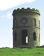
Solomon's Temple, also known as Grinlow Tower, is a Victorian folly on the summit of Grin Low hill, near the spa town of Buxton in the Derbyshire Peak District.On 23 February 1894, a meeting at Buxton Town Hall decided to rebuild a landmark tower that had been built by Solomon Mycock, of the Cheshire Cheese Hotel, in the early 19th century, and of which only a few stones remained. The Local Board vice-chairman had talked with the seventh Duke of Devonshire's agent and decided that the reconstruction was feasible if the townspeople would donate sufficient money. Sketches were submitted by architects W. R. Bryden and G. E. Garlick. By that May, the plans were confirmed by the Duke of Devonshire, and it was well known that the site was of prehistoric importance. In June 1894, the seventh Duke of Devonshire subscribed £25 towards building the folly. Buxton had already subscribed £50. The foundation stone was laid by Colonel Sidebottom, M.P., on 31 May 1896, witnessed by a large crowd, and the tower was opened by Victor Cavendish in September 1896. The tower was restored in 1988 by public subscription.The structure is a 20-foot-high (6.1 m), two-storey tower built on top of a Bronze Age barrow, sitting on top of a ridge at a height of 440 metres (1,440 ft) above sea level. From the open top of the tower there are good 360-degree views over the town and the surrounding countryside and parts of the Peak District. The tower does not contain anything other than the staircase to the top. It is a Grade II listed building.