place

Howe, Norfolk

AC with 0 elementsCivil parishes in NorfolkNorfolk geography stubsVillages in Norfolk
Howe g3
Howe g3

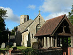
Howe is a village and civil parish in South Norfolk, England. It is situated between Poringland, Brooke and Shotesham. It covers an area of 3.20 km2 (1.24 sq mi) and had a population of 54 in 21 households at the 2001 census.Howe, from the Old Norse word haugr, is a Middle English topographic name for someone who lived by a small hill or a man-made mound or barrow. St Mary's church is one of 124 existing round-tower churches in Norfolk, showing many signs of construction in the Anglo-Saxon period, such as tall proportions, splayed porthole windows, and flint quoins. The ample-sized tower dates from the pre-Conquest period, being one of a series of Saxon round towers in Norfolk that demonstrate that the round tower design is at least 1000 years old. Several other features are of interest to the student of local church architecture. The church can be reached from Poringland, approx. 2 km away, along a lane through an open arable field, where another, later, round tower can be seen. There is a regular bus service from Norwich.

Excerpt from the Wikipedia article Howe, Norfolk (License: CC BY-SA 3.0, Authors, Images).

Howe, Norfolk
Howe Green, South Norfolk

Geographical coordinates (GPS) Address Nearby Places
placeShow on map

Wikipedia: Howe, NorfolkContinue reading on Wikipedia

Geographical coordinates (GPS)

Latitude Longitude
N 52.55061 ° E 1.35565 °
placeShow on map

Address

Howe Green

Howe Green
NR15 1HD South Norfolk
England, United Kingdom
mapOpen on Google Maps

Howe g3
Howe g3
Share experience

Nearby Places

Poringland
Poringland

Poringland is a village in the district of South Norfolk, England. It lies 5 miles (8.0 km) south of Norwich city centre and 10 miles (16 km) north of Bungay. Its population has rapidly grown in the past 50 years. It covers an area of 6.32 km2 (2.44 sq mi) and had a population of 3,261 living in 1,403 households at the 2001 census, the population increasing to 3,802 at the 2011 Census.Poringland was previously also known as both East Poringland and Great Poringland, and was part of the ancient Hundred of Henstead. The place-name 'Poringland' is first attested in the Domesday Book of 1086, where it appears as 'Porringhelanda', the meaning of which is uncertain. Some believe the name derives from 'Poor spring land', because it has poor soil, containing much clay. This village contains many public services. These include two pubs, a supermarket, estate agents, takeaways, a restaurant and various shops. The church of Poringland All Saints is one of 124 existing round-tower churches in Norfolk. The village sign, which stands close to the church and the village pond, depicts the artist John Crome, founder of the Norwich School of artists, working on his famous painting 'The Poringland Oak'. Cromes Oak Close in the village is named after the artist. Many of Crome's paintings are available to view at the Norwich Castle Museum. The original of the Poringland Oak hangs in Room 7 at Tate Britain. The village of Framingham Earl which borders Poringland, contains the local High School. The River Chet (Norfolk) rises in Poringland. The German writer W.G. Sebald lived in Poringland until his death in a car crash in 2001. A former Norwich City and Scotland international footballer Robert Fleck also lived in Poringland. Ronan Parke, runner-up of Britain's Got Talent in 2011, also resides in the village. As does former Norwich City and Everton manager, Mike Walker.

Framingham Earl
Framingham Earl

Framingham Earl is a small village situated south of Norwich, in the English county of Norfolk. It is next to Poringland and Framingham Pigot. It covers an area of 2.56 km2 (0.99 sq mi) and had a population of 834 in 354 households at the 2001 census, increasing to a population of 871 in 363 households at the 2011 Census. The villages name means 'Homestead/village of Fram's people'. The village was held by the Earl of Norfolk hence the 'Earl' addition. Within Framingham Earl is Framingham Earl High School, which is part of the Sapientia Education Trust. Sharing the same site is a Sports Centre, which opened in early 2006 and provides a range of exercise classes and sports opportunities to the people of the surrounding villages as well as giving the school extra space to use for PE and dance lessons. It is now managed by South Norfolk District Council. [1] The village has two churches, the Methodist Church and the Church of St. Andrew′s. St. Andrew's is one of 124 existing round-tower churches in Norfolk. The plan of the church is beguilingly irregular, with the chancel decreasing in width towards the east end. A pilaster strip in the south wall of the chancel curiously tapers with the narrow portion at the bottom: the whole building has a gnarled, irregular appearance which is a mark of Anglo-Saxon construction. Even the corners (quoins) are of flint, although these are somewhat larger on the whole than those built into the body of the walls. There is even, surprisingly, an attempt at herringbone-work, all in flint, and round splayed porthole windows dressed entirely in flints, not quite perfect circles. The German writer W. G. Sebald is buried in the churchyard of St. Andrew's.