Churchgate
MaharashtraMumbaiMumbai geography stubsNeighbourhoods in MumbaiUse Indian English from May 2018

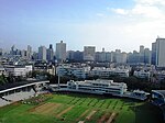
Churchgate (Marathi pronunciation: [t͡ʃəɾt͡ʃɡeːʈ]) is an area in South Mumbai. During the eighteenth and up to the mid-19th century, Mumbai was a walled city. The city walls had three gates, and Churchgate, named after St. Thomas Cathedral, Mumbai was one of the gates. The gate was situated near the present day location of Flora Fountain. In the mid-19th century, the city walls were torn down to aid in the expansion program.Arabian Sea is situated at west and Nariman Point on south of Churchgate. Churchgate railway station is a major railway terminus on the Western line of the Mumbai Suburban Railway.
Excerpt from the Wikipedia article Churchgate (License: CC BY-SA 3.0, Authors, Images).Churchgate
Sir Dorab Tata Road, Mumbai A Ward (Zone 1)
Geographical coordinates (GPS) Address Nearby Places Show on map
Geographical coordinates (GPS)
| Latitude | Longitude |
|---|---|
| N 18.93 ° | E 72.82 ° |
Address
Sir Dorab Tata Road
Sir Dorab Tata Road
400023 Mumbai, A Ward (Zone 1)
Maharashtra, India
Open on Google Maps


