place

Newton Mearns

Commons category link is locally definedGreater GlasgowJews and Judaism in ScotlandNewton MearnsPopulated places established in 1832
Towns in East Renfrewshire
Mearns Cross geograph.org.uk 17337

Newton Mearns (Scots: The Mearns; Scottish Gaelic: Baile Ùr na Maoirne [ˈpalə ˈuːɾ nə ˈmɯːrˠɲə]) is a suburban town and the largest settlement in East Renfrewshire, Scotland. It lies 7 miles (11 km) southwest of Glasgow City Centre on the main road to Ayrshire, 410 feet (125 m) above sea level. It has a population of approximately 26,993, stretching from Whitecraigs and Kirkhill in the northeast to Maidenhill in the southeast, to Westacres and Greenlaw in the west and Capelrig/Patterton in the northwest.It is part of the Greater Glasgow conurbation. Its name derives from being a new town of the Mearns (from Scottish Gaelic "a' Mhaoirne" meaning a stewartry).

Excerpt from the Wikipedia article Newton Mearns (License: CC BY-SA 3.0, Authors, Images).

Newton Mearns
Ayr Road,

Geographical coordinates (GPS) Address Nearby Places
placeShow on map

Wikipedia: Newton MearnsContinue reading on Wikipedia

Geographical coordinates (GPS)

Latitude Longitude
N 55.7716 ° E -4.3347 °
placeShow on map

Address

Ayr Road

Ayr Road
G77 6AE , Paidmyre
Scotland, United Kingdom
mapOpen on Google Maps

Mearns Cross geograph.org.uk 17337
Share experience

Nearby Places

Capelrig House
Capelrig House

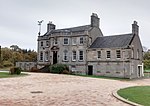
Capelrig House is an 18th-century house in Newton Mearns, East Renfrewshire, Scotland, upon whose lands is situated Eastwood High School. The house is protected as a Category A listed building.The lands of Capelrig were held by the Knights Templar in the 12th century. Upon the suppression of the Templars, their property passed to the Knights Hospitaller. At the time of the Scottish Reformation, the Hospitallers' lands were surrendered to the Crown, but were returned by Mary, Queen of Scots to Sir James Sandilands, the last preceptor of the Hospitallers in Scotland.Capelrig was later acquired by the Mure family of Caldwell. The Mures sided with the Covenanters during the religious conflicts of the 17th century, and Capelrig was briefly taken by the Royalist General Tam Dalyell of the Binns. The family regained their lands upon the Glorious Revolution of 1688. In 1765 Capelrig Estate was bought by Robert Barclay, whose mentor was William Mure and who gave him a lucrative post as a tax collector, becoming Depute Admiral of the Clyde. Barclay was regarded as the best whist player in Glasgow in his day and was a lawyer in the city in the firm of Barclay & Grahame. In 1769 a new house was erected, the present house in the Georgian style. It and the Estate descended through his family to James Barclay Murdoch, noted historian and antiquarian - and himself a descendant of the Browns and of the Murdochs who were Provosts of Glasgow. A wing was added to the south-west in 1913 by its new owner Kenneth Weir, on the occasion of his marriage. He later became the 2nd Viscount Weir of Eastwood. Much of the Estate continued to be owned by the Murdoch Trust families. In 1948 Kenneth Weir sold the House and farmlands to John Lawrence & Co Ltd, housebuilders, To provide for a new school Capelrig House and its immediate policies were purchased by the then Council of County of Renfrew who wished to demolish the building but were dissuaded after a public outcry. It was refurbished as an arts centre, and has been used as offices by East Renfrewshire Council.

Pollock Castle
Pollock Castle

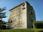
Pollock Castle, also known as Pollok Castle, was a tower house castle located to the west of modern Newton Mearns in East Renfrewshire, on the opposite side of the M77 motorway from the town. The castle appears on Timothy Pont's map (1583–96), as a castle named Pook and also appears on Joan Blaeu's map of 1654.The castle was rebuilt between 1686 and 1694 by Sir Robert Pollok, 1st Baronet of Pollok, with a new east wing. Further extensions included an enclosing courtyard with an ornate gateway and formal walled garden with corner pavilions. William Roy's map (1747–55) shows the castle and landscape in detail.It was destroyed by fire in 1882, but rebuilt afterwards in 1886 in the Scots Baronial Style architecture, incorporating the surviving elements of the earlier structure. It was requisitioned by the British Army in 1939 during World War II, bar one wing occupied by the Pollok family throughout the war and the lands used as an ammunition dump. In 1944, Miss Fergusson Pollok, the then owner, abandoned the castle and it then deteriorated. It was required to be demolished in 1952. In 1970, all that remained of the castle were the two gatehouses, the stable, and the gardener's cottage, the castle's stone foundations, the south entrance steps and a few stones that once formed the castle's massive walls. Some of the ruins were dynamited in the 1970s and a large prefabricated house erected on the castle foundations by Mr Greer, who purchased Pollok Castle Estate from a timber merchant. The gatehouses at each end of the estate were also rebuilt, along with the gardener's house and the castle stables, and sold on as private residences. The prefabricated house was removed and the site cleared in the early 1990s and the castle was again rebuilt in 2003, in the Scottish Adam style. Some of the original foundations and castle walls remain, on which the house has been built, notably a portion of the five-meter-high (16 ft) north wall still remains.